Another round of hefty rain impacting Montgomery, northern Harris, and Liberty Counties this morning

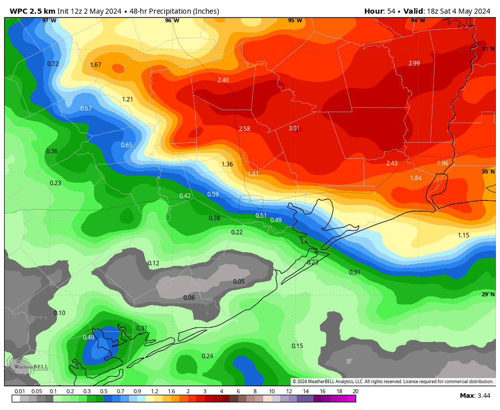
In brief: Flash flood warnings are in effect for Montgomery, far northern Harris, and Liberty Counties this morning, as an additional 1 to 4 inches of rain has fallen. River flooding will continue in those areas as well, with numerous evacuation orders and road closures in effect. Major rain should hopefully exit this morning with more intermittent, scattered downpours through the day. Additional storm chances exist tonight and especially Sunday before the heat sets in next week.

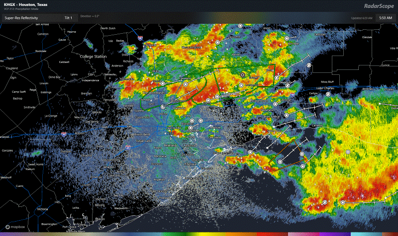
A flash flood warning is in effect north of Houston through 8 AM, as another batch of heavy rain fired up overnight dropping 1 to 4 inches of rain between southern Montgomery, northeast Harris, and northern Liberty Counties.

Rain totals over the last few hours have been as high as 3 to 4 inches just south of The Woodlands. An additional 1 to 2 inches is possible before (hopefully) things settle a bit this morning. (NOAA)

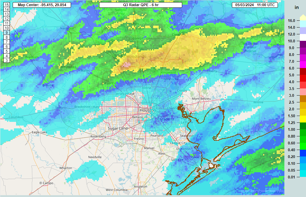
This is not where we wanted to see the rain this morning. We do expect that this will actually move along at a better clip than yesterday’s rain did. Hopefully that leads to some quicker improvement, but all this water will help further swell the river systems up there. You can view flood gauge information on rivers, creeks, and bayous at the National Weather Service or at Harris County Flood Control. Please follow the advice of your local officials, and never drive around barricades.

A Flood Watch remains in effect along and north of I-10, extended through Saturday, and we will maintain our Stage 1 flood alert for Houston.

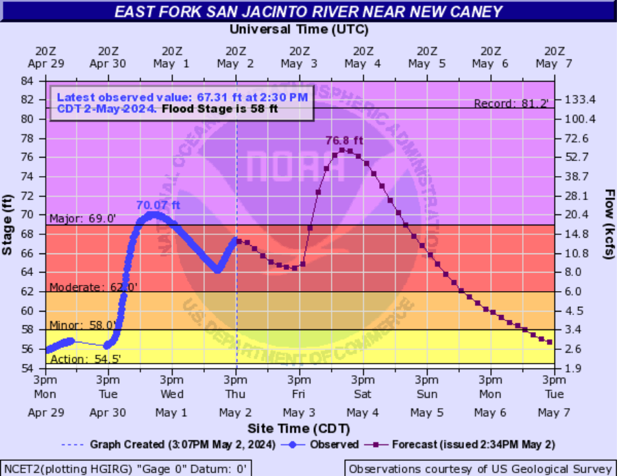
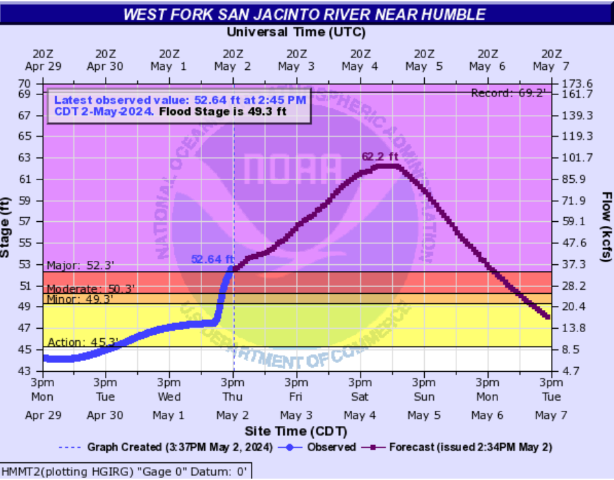
The San Jacinto and Trinity Rivers remain the two most serious issues at this time. There will continue to be rises and damaging flooding within both systems. Additionally, the Navasota River is expected to crest at record levels north of Bryan. That feeds the Brazos, and we’re likely to see high water or minor flooding begin in that river too as we head into next week. Thankfully, we aren’t expecting a whole lot worse in that system. A lot happening, and we’ll keep you posted on any significant changes with at least one more update later today.

Today

The rest of this morning is expected to see this very heavy stuff north of Houston exit east and be replaced by more in the way of scattered thunderstorms.

Heavy rain should hopefully exit to the east this morning, being replaced by more scattered thunderstorms, notable but more manageable than the current rain. (RadarScope)

If we can pop more in the way of scattered storms, yes, that will lead to isolated heavy downpours, but more often than not it wouldn’t rain over one place hard for more than 15-20 minutes at a time. Even a few rounds of that is more manageable than the deluge and 2 to 6 inch per hour rates we’ve seen this week. We’ll continue watching and keep you posted. Have an umbrella and an indoor backup plan anywhere in the area today just in case. Highs will range from the upper-70s in places it rains persistently to low-80s. Showers should diminish in coverage this evening.

Saturday

Do we expect more showers and storms to fire up overnight tonight and Saturday morning? It’s NBA playoff season, so in the words of Marv Albert, “Yes!” Unfortunately we will probably see additional rains in saturated and flood-impacted areas north of Houston. There is a chance that this ends up being a little less rain than today, so hopefully that’s the case. Otherwise, sun, clouds, and 80s.

Sunday

The back half of the weekend looks to remain unsettled. Another wave of storms could pass through the area in the morning or afternoon hours, especially north of I-10, again. Rainfall could again be heavy, and right now I am a little more concerned about Sunday than Saturday in terms of rain and impacts. Outside of any storms, expect clouds, some sun, and highs in the 80s.

Next week

I wouldn’t be shocked to see one more round of showers or storms on Monday or Tuesday, but then the heat cranks up. Expect upper 80s on Monday, low-90s by Tuesday, and low to mid-90s on Wednesday and Thursday.

NWS forecast high temperatures for next Thursday are…hot. (Pivotal Weather)

It will feel uncomfortably hot, given this is first real heat of the summer season, so take it easy. Morning lows will generally be in the mid-70s. We may see rain chances return toward the weekend but for now that’s mostly speculation, and I wouldn’t be changing any Mother’s Day plans at this time.

Worst of heavy rainfall likely over, but some redevelopment is possible late tonight and on Friday

In brief: The heavy rainfall has exited the Houston area, for now at least. The thunderstorms dropped 1 to 3 inches of rain across the southern half of the region, but some whopping totals of up to 8 inches near locations such as Spring and Kingwood during a few hours today. We may see some additional rains tonight and on Friday, but we are confident that the worst is over.

As of about 4:30 pm this afternoon, the mass of showers and thunderstorms that brought widespread rain to Houston today has exited to the east. The atmosphere is now pretty worked over, so we should see fairly calm conditions for the rest of this afternoon and evening. And after that? There is the possibility of scattered showers and thunderstorms returning after midnight, especially for areas south of Interstate 10. Overall these areas have not been particularly hard hit, so I’m not particularly concerned about these storms in terms of flooding. Because the worst is likely over, we are stepping back our flood alert to Stage 1.

We may see another round of showers develop during the morning hours on Friday and persist into the afternoon. Given the messy forecast today, I’m not particularly confident in anything tomorrow. However I don’t anticipate it being nearly so potent as the system we saw today. Matt will have all the details first thing on Friday morning, when we should have the forecast better in hand.

The big story now is river flooding due to the incredible amounts of rain that fell north of Houston this week, including Wednesday night. Lakes Conroe and Livingston were particularly inundated. The National Weather Service has a map where you can find detailed flooding forecasts for various rivers in the greater Southeast Texas area here.

River flooding

Among the biggest concerns are the East and West Forks of the San Jacinto River. Already a mandatory evacuation is in effect for the eastern side of the river, from FM 1485 to Lake Houston. According to Jeff Lindner of the Harris County Flood Control District, forecasted water levels on the East Fork will rise 7 to 8 feet higher than earlier this week. Structures on the ground will be flooded to rooftops levels. Elevated structures will be flooded. For reference, the forecasted water level is only 3 feet below those of Hurricane Harvey.

Flood information for the East Fork of the San Jacinto River near New Caney. (NWS)

Conditions are also serious along the West Fork of the river. Lindner says the river is rapidly rising from upstream inflows, and will rise to near 62 feet on Saturday. Widespread low land flooding will occur impacting the following subdivisions: Belleau Woods, Rivercrest, Northshore, Forest Cove, Kings Point, and Atascocita Shores. Flooding of streets in Kingwood, as well as lower structures near the river will also be possible.

Flood information for the West Fork of the San Jacinto River near Humble. (NWS)

If you live in flood-affected areas please do not drive into high water.

Well, that escalated quickly: The worst of the storms is coming sooner than expected to Houston

In brief: Due to the unanticipated escalation in storm activity this morning, it now appears as though the city of Houston will see intense showers and thunderstorms during the next several hours, through Thursday afternoon. We are issuing a Stage 2 flood alert for the entire area due to the high rainfall rates and timing of street flooding.

We were wrong. Just hours ago, in this morning’s post, it looked as though a band of showers north of the region would slowly wane through the morning hours. However, as we’ve been monitoring radar trends, that clearly has not happened. Instead we’ve seen this band thicken and slowly progress southward toward central Houston. Already in locations such as Spring, Humble, and Atascocita have picked up in excess of 5 inches in just a couple of hours this morning. That is a lot of water in a little time.

Although there remains considerable uncertainty, it now appears as though this line of storms will continue to sag southward this morning before reaching the coast by late afternoon. It is likely to have significant impacts in the city of Houston and surrounding areas, including street flooding. Of particular immediate concern is the high rainfall rates associated with these storms, which will back roads up quickly. For this reason we are escalating to a Stage 2 flood alert for the entire region. Conditions should hopefully improve late this afternoon or evening.

All of this activity should have an impact on the atmosphere, and because of this it no longer appears as though the region will see a round of stronger storms overnight, into Friday morning. But given the unpredictability of this system so far, that is not an entirely confident prediction.

Please stay safe today and do not drive into high water.

Very heavy rainfall continues north of the Houston metro area, focus may shift south by early Friday

In brief: Houston has largely been spared by heavy rainfall during the last two days, but the story has been different to the north of our region, especially along and north of Highway 105. This could change beginning late Thursday night, when the city of Houston will see the potential for heavy rainfall. Next week still looks rather hot.

It has been a wet and stormy night for areas north of Houston, including locations such as College Station, Huntsville, and Livingston. Since Wednesday evening, accumulations for areas north of Lake Conroe and around Lake Livingston have reached 7 to 10 inches, leading to flash flooding. This is certain to lead to additional, significant downstream flooding along the San Jacinto and Trinity rivers during the coming days.

Rain totals from 6 pm Wednesday to 6 am Thursday show a sharp increase in accumulations north of Highway 105. (Harris County Flood Control District)

So far Harris and surrounding counties have been spared by the latest round of showers. Although the atmospheric conditions supporting heavy rain remain most favorable for locations north of the Houston metro area in the coming days, some of this activity will push southward. At this time, the most likely period for heavy rainfall across the Houston metro area will now come early on Friday.

To that end we are maintaining a Stage 1 flood alert for the Houston area today and Friday. For the northern locations described above, the regions around the lakes Conroe and Livingston, we are definitely approaching Stage 3 conditions on our flood scale. But I want to be clear that, for now, we don’t expect that kind of flash flooding conditions in the Houston metro area. It really has been a sharp gradient in rainfall. For example, during the last two days The Woodlands has recorded less than one-quarter of an inch of rain. Less than 30 miles to the north, New Waverly has received nearly 8 inches.

Thursday

I expect the band of heavy rainfall to the north of the Houston metro area to persist through the morning hours before there is some weakening. It will likely move slightly south, covering much of Montgomery County, but it should be diminishing in intensity through the morning hours. Later this afternoon I expect to see some scattered showers and thunderstorms pop up across Houston, but at this time they don’t look too terribly organized. For the most part, in the city of Houston and points south, we should see partly to mostly cloudy skies with muggy air and highs in the mid-80s. There likely will be a bit of a break from showers this evening for the area.

Thursday night into Friday morning

While there is the usual uncertainty, it does appear as though another round of showers and thunderstorms will develop later on Thursday night, likely after midnight. At this time there is a greater likelihood of rainfall across most of the Houston area, including locations south of Interstate 10. Roughly speaking, there is the potential for an additional 1 to 4 inches of rainfall accumulations, with the risk for higher totals running from the wee hours of Friday morning into the middle of the day.

There could be some higher bullseyes. I don’t feel overly confident in the details of this forecast, so expect an update on this website later this afternoon as we get better data. The bottom line is that it could be a wet night for Houston, but I’m not guaranteeing it. Because of this potential for additional rain tonight into Friday, we’re holding on to the Stage 1 flood alert for the entire Houston area.

NOAA rain accumulation forecast from noon Thursday to noon Saturday. (Weather Bell)

Friday

We probably will see the heavy rainfall threat ending later on Friday, so expect partially clearing skies to go along with highs in the low- to mid-80s during the afternoon hours.

Saturday and Sunday

The weekend, for the most part, should bring partly sunny skies and modestly warm weather to Houston. Look for highs in the mid-80s. While rain chances overall in Houston are quite low, they are not zero. Unfortunately, chances appear to be a bit higher for locations north of the city, including the hard hit areas north of Highway 105 described above. To be clear we’re not talking about inches and inches more of rain, but there will be the potential for additional showers and thunderstorms this weekend.

Next week

We’re still looking at the warmest weather we’ve seen so far in 2024 next week. Expect highs in the low-90s by mid-week, with plenty of humidity to make it feel rather warm out. It’s not full on summer, but it will definitely feel hot since it’s been half a year since we’ve felt heat like this. There is a chance, but only a chance, that we may see a final, weak-ish front trail into the area some time next weekend to bring us some drier air. A man can hope …