Flash flooding a good possibility in some spots northwest of Houston later today

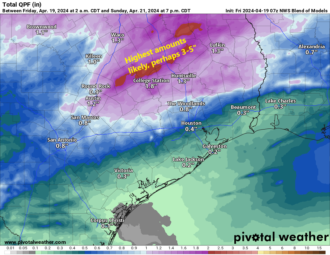
Summary: We are hoisting a Stage 1 flood alert for areas northwest of Houston that should see heavy rain later today. Street flooding is a good bet in those areas. Houston and points south and east will see substantially less rainfall. Things quiet down and cool down tomorrow.

Good morning! We covered the forecast mostly fine yesterday, but now that things are in focus, we can fine tune some details for you for today. First off, we are going to issue a Stage 1 flood alert on our Flood Scale for areas northwest of Houston. This means that we expect street flooding in spots, and it’s possible that we see some decent rises on some of the creeks or rivers in those areas. We could see enough rain to impact the Spring or Cypress Creek watersheds, among some others. Also, the larger river systems north or northwest of Houston (Brazos, San Jacinto, Trinity) could see some decent rises.

We have established a stage 1 flood alert, meaning street flooding is possible to likely in spots for areas northwest of Houston. Flooding is unlikely south and east of Houston, and there will be an extremely sharp cutoff in rain totals. (Pivotal Weather)

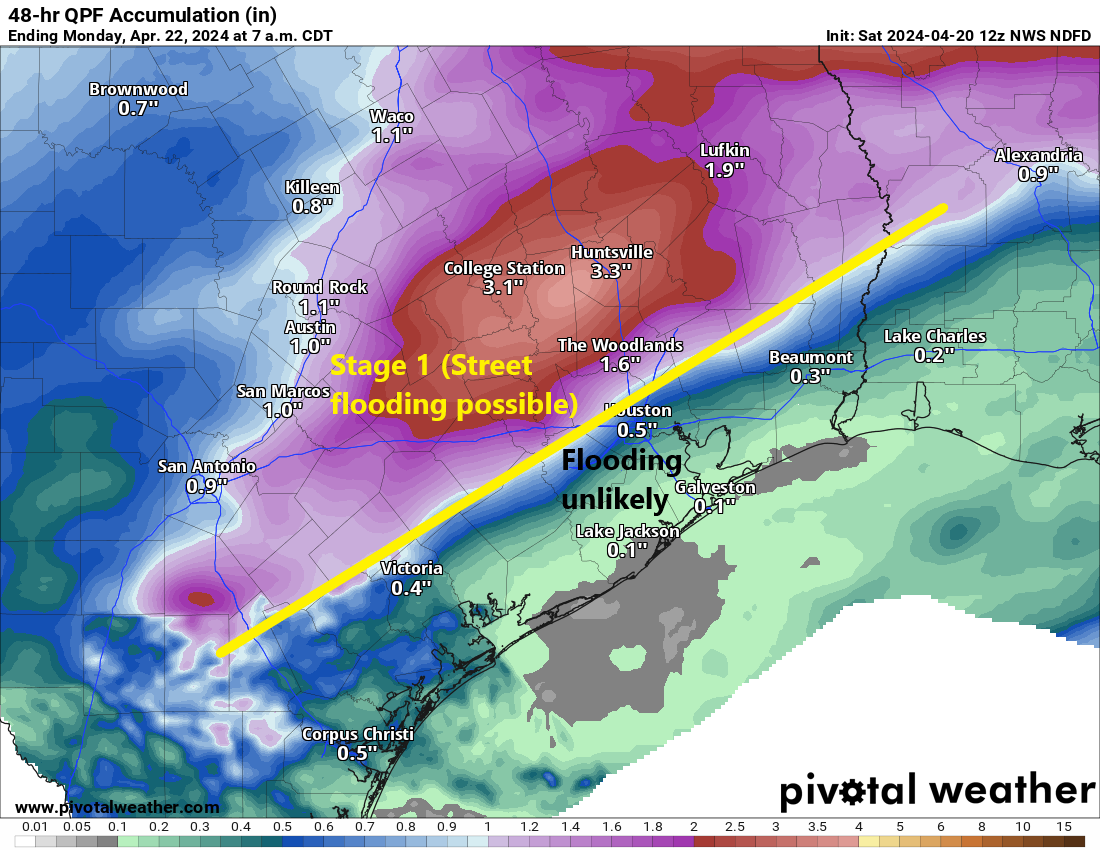
Unique about this particular setup: Areas south and east of Houston may see minimal rainfall. Some places may even see no rain at all.

Here are a few more notes about this event.

Timing: There are already a few showers south of Victoria moving toward Matagorda, and through early afternoon a handful of isolated showers are possible. Most folks will be fine though. Between about 2 and 6 PM, we expect more isolated showers or storms anywhere in the area, eventually focusing northwest of Houston by evening in the areas of concern noted above. If you’re attending the Dynamo game this evening, I’m not too worried, but don’t be entirely shocked if it rains a bit or there is a brief lightning delay at some point. The worst rains north and west of Houston will be from about 6 PM through midnight, with everything eventually getting pushed east overnight and out of the area by morning. Some clouds or light rain will be possible Sunday morning.

Rain totals: You can see the forecast above, but there are risks. Houston and points south and east will see an inch or less, probably less than a half-inch in most spots. As you progress north and west from Downtown Houston, we should quickly see totals of 1 to 3 inches. In extreme northwest Harris County, Montgomery County, portions of Waller County, and north of there, expect 2 to 4 inches. A few locations in those areas will likely see 4 to 7 inches of rain, if not a bit more. This is where we are most concerned with flooding.

An NWS Houston graphic laying out the risk of flooding and higher rain totals northwest of Houston tonight. (NWS Houston)

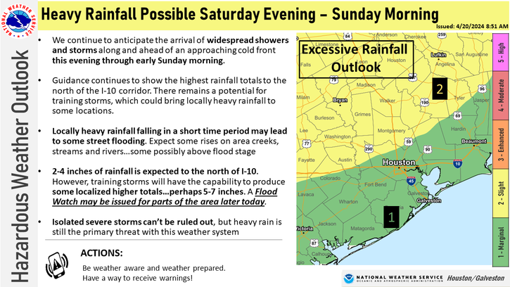
Again, there will likely be a sharp cutoff between 1 to 2 inch rains and minimal rain somewhere in the Houston area.

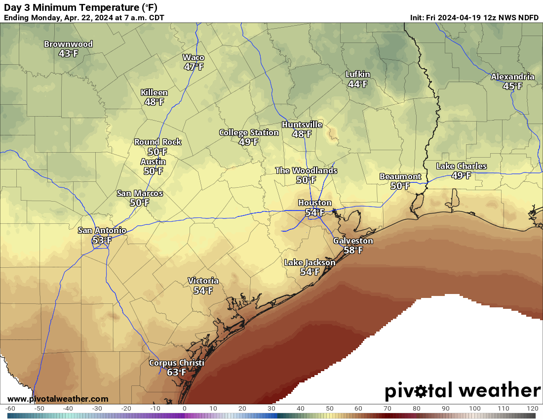
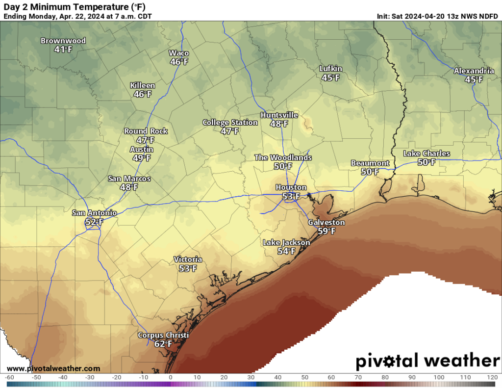
And Sunday? Cooler! Look for breezy conditions and temperatures stuck in the 60s for most of tomorrow. Some light rain or a few showers may linger in the morning, with gradual PM clearing. Overnight lows into Monday morning still look to be in the 40s and 50s.

Monday morning lows will probably require a light jacket! (Pivotal Weather)

Should anything serious change, we’ll update you later. Otherwise, just stay safe and make sure you stay weather aware, especially northwest of Houston later today.

Pleasant weather is in sight for a couple days, but first Houston must deal with some rain and storms this weekend

Summary: Cooler weather is in sight as we head later into the weekend. Before that, it will be warm to hot and humid, and there will likely be heavy rain and strong storms north and northwest of Houston on Saturday evening. If you’re traveling north and west toward Austin, Waco, or Dallas Saturday afternoon or evening, use caution.

Today

We hit 88 degrees yesterday in what felt like an early summer preview. Expect more of the same today, though we could shave a couple degrees off yesterday’s temperatures with more clouds possible. An isolated shower or storm is possible, much like we saw yesterday across the area. This would be most likely in the afternoon hours.

Saturday into Sunday

The forecast gets more interesting here. As of now, Saturday morning looks warm, humid, but otherwise fine. An isolated shower or storm is possible from late morning into early afternoon. By mid to late afternoon, storm coverage should increase. Here’s how we expect it to go right now.

Storms could develop in the Houston area, along and north or west of US-59/I-69 after 2 to 3 PM. I suspect those storms will lift north and west a bit and eventually line up robustly between about College Station and Huntsville. There is some signal within the models of training storms up that way, so rain could continue to repetitively cycle over the same areas a bit. Eventually, as the front plows south and east, all of those storms will come with it. That should sweep back through the Greater Houston area between midnight and 5 AM or so. It will continue to progress east and out of our area on Sunday.

Rain totals will vary this weekend, with the highest amounts likely north and northwest of Houston, where as much as 3 to 5 inches could fall, leading to some flash flooding. (Pivotal Weather)

How much rain? I think we’re going to see a lot of variability, truthfully. From Houston south and east, probably a half-inch or less, unless the overnight storms pack more punch than we currently expect. Within Houston and the immediate suburbs north and west (Katy through Cypress and The Woodlands), we will probably see anywhere from a quarter-inch to an inch or more in an isolated spot or two. Farther north and west, along a line from about La Grange through College Station through Huntsville, rain totals will likely average 1 to 3 inches, and I would not be the least bit shocked to see someone end up with 5 inches or even a little more out of this. Flash flooding is a definite possibility up that way, and if you’re traveling between Houston and Dallas, Waco, or Austin tomorrow afternoon or evening, just be aware of this potential.

On Sunday afternoon, things should clear out, and the humidity will take a plunge.

Saturday’s highs will again be in the 80s, with morning lows in the 70s. Temperatures should drop into the 60s with the storms Sunday morning before recovering back to near 70 degrees in the afternoon. It will be noticeably cooler and breezy.

Next week

Monday looks absolutely spectacular for late April. Expect lows in the 50s (or even a handful of 40s!), highs in the low to mid-70s, and plentiful sunshine.

Monday morning will be one of our last truly cool mornings until autumn. (Pivotal Weather)

Tuesday should be similar humidity-wise but a touch warmer with lows near 60 and highs around 80 or a little hotter. The weather pattern may get a bit more unsettled for late week. Along with very warm highs well into the 80s to perhaps near 90 later next week, each day will have a slight chance of showers or thunderstorms. Details are still TBD. I don’t want to speculate a ton on next weekend yet, with plenty of big athletic events on tap. I don’t think the MS 150 riders will be enduring much of a headwind, but the rest of the forecast is up in the air. More to come.

Showers likely this weekend, with heavy rain possible north of Houston

Summary: Houston faces a few more warm days before we get a brief reprieve from the heat and humidity starting on Sunday. We’re also watching for the potential of heavy rainfall to the north of Houston on Saturday night in association with the cool front.

As of Thursday morning near sunrise, it’s not difficult to spot the location of a front moving across Texas. (Weather Bell)

Thursday

You guessed it, more warm and humid weather is on the way for Houston today. High temperatures will reach the mid-80s in the city, with the possibility of upper-80s if we get much sunshine this afternoon. And that’s possible, with the potential for a few breaks in the clouds after this morning. Winds will blow from the southeast at 10 to 15 mph with higher gusts, and rain chances are about 10 percent. Lows tonight will only drop into the low 70s.

Friday

If you liked Thursday, you’re in luck. Friday will be much the same. Highs again will be in the mid- to upper-80s with plenty of humidity. Expect another warm night.

Saturday

Most of Saturday looks fine, if warm, for outdoor activities. Highs will be slightly cooler, but still in the low- to mid-80s with cloudy skies. Some light showers will be possible in Houston during the afternoon and evening hours, but we’re not expecting anything wild ahead of a frontal push overnight.

The forecast begins to change Saturday evening, or perhaps during the overnight hours. Showers and thunderstorms will mass to our northwest, with areas such as College Station at risk of 2 or more inches of rain, with higher bullseyes. How much of this heavier rainfall filters down into Houston is an open question, however. At this point I expect milder conditions in the city, and down to the coast, where accumulations of 0.25 to 0.75 inch of rain appear more likely. Thunderstorms will be possible, although less likely. Lows on Saturday night should drop into the mid-60s.

Sunday

A chance of showers will linger in the morning, near the coast. But for the most part this should be a cloudy and cooler day, with highs in the lower 70s, and lower humidity. We’re going to get one fairly cool night with this front, and it comes Sunday night. Most of the city will drop into the 50s heading into Monday morning.

Low temperature forecast for Sunday night in Houston. (Weather Bell)

Next week

Monday should also see highs in the 70s before the onshore flow really starts ripping again. We’ll accordingly warm up, and will likely reach the mid-80s by mid-week, and upper-80s toward the end of next week. Highs potentially in the 90s are definitely in play, but we’ll have to see how things shake out.

We’ve got a couple of major outdoor athletic endeavors next weekend, the Texas Bike MS 150 and IRONMAN Texas event in The Woodlands. A precise forecast remains impossible, but the overall pattern looks warm and humid. I’m guessing highs in the upper 80s, with a fairly pronounced southerly wind. Rain chances, at this vantage point, continue to look fairly low.

Houston flirting with record warm nights as a humid pattern continues into the weekend

Summary: Our warm pattern continues, with humid days and sultry nights heading into the weekend. Then, with the approach of a front, we’ll see widespread showers and some thunderstorms. These will likely peak on Saturday night and Sunday morning before drier air starts to move in and we see a couple of cooler nights.

Wednesday

As I write this low temperatures outside are in the mid-70s for much of Houston, with a relative humidity of around 90 percent. That is not quite summer-like sticky, but it is definitely rather warm for April. The record high minimum temperature for today, April 17, is 74 degrees. The city’s official monitoring station briefly hit 74 degrees this morning, so it’s likely we’ll tie the record for warmest low temperature for today.

The warm and sticky weather will continue into the weekend. Highs today are likely to top out in the mid-80s, with mostly cloudy skies. Winds will be light, generally from the south at 10 mph or so with higher gusts. It will be another warm evening, but there is enough moisture about to potentially generate some light shower activity later this evening, perhaps after 9 pm, and into the wee hours on Thursday morning. Don’t expect much in the way of accumulations. Any showers are likely to be fairly scattered.

Friday will bring highs in the upper-80s to most of the Houston region. (Weather Bell)

Thursday and Friday

These will be a pair of warm and mostly cloudy days. Expect highs in the mid- to upper-80s with plenty of humidity, and southerly winds at about 10 mph with higher gusts. While there will be plenty of moisture in the atmosphere, a stout capping inversion will be in place that should limit rain chances to 10 or 20 percent each day. Nights remain warm, in the low- to mid-70s.

Saturday and Sunday

A cold front will approach the region this weekend, and eventually move through the area early on Sunday morning. This will determine our weather, and when and where we see rainfall. For now, I expect Saturday to see mostly cloudy skies, highs in the mid 80s, with scattered rain showers. Rain chances will increase on Saturday evening, and through the overnight hours, as the front nears and passes. At this point, rain chances look to be higher, along with a greater potential for heavy rainfall, for locations north of Interstate 10. There is, as yet, no strong signal for severe weather beyond typical thunderstorms.

Sunday will be cooler, with highs likely in the low 70s. Although some drier air will be moving in, some showers may linger near the coast in the morning. Skies should start to clear some during the afternoon hours. Lows on Sunday night will drop into the 50s for most of the area. This may be the only night in the 50s with this front, so enjoy the cooler and drier air.

There will be a decent chill in the air on Monday morning. (Weather Bell)

Next week

Monday will be another pleasant spring day with drier air, a fair amount of sunshine, and highs of perhaps 80 degrees. After that we’ll start to warm back up with a fair bit of humidity. Look for highs in the mid- to upper-80s during the second half of next week.

If you’re planning to participate in the Texas Bike MS 150, it’s still too early to have too much confidence in the forecast. There’s no strong indication of rainfall or storms, and the most likely outlook is fairly warm and humid weather. That would tend to imply a nice southerly or southeasterly breeze for the rides to La Grange and College Station, but I would be a fool to try and predict winds this far out.