Showers likely this weekend, with heavy rain possible north of Houston

Summary: Houston faces a few more warm days before we get a brief reprieve from the heat and humidity starting on Sunday. We’re also watching for the potential of heavy rainfall to the north of Houston on Saturday night in association with the cool front.

As of Thursday morning near sunrise, it’s not difficult to spot the location of a front moving across Texas. (Weather Bell)

Thursday

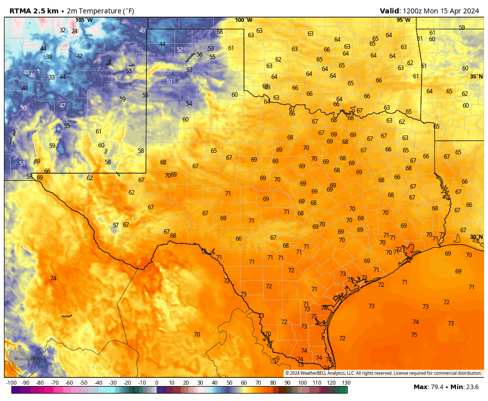
You guessed it, more warm and humid weather is on the way for Houston today. High temperatures will reach the mid-80s in the city, with the possibility of upper-80s if we get much sunshine this afternoon. And that’s possible, with the potential for a few breaks in the clouds after this morning. Winds will blow from the southeast at 10 to 15 mph with higher gusts, and rain chances are about 10 percent. Lows tonight will only drop into the low 70s.
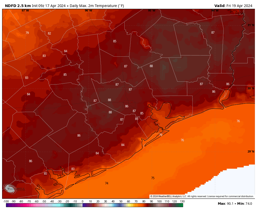
Friday

If you liked Thursday, you’re in luck. Friday will be much the same. Highs again will be in the mid- to upper-80s with plenty of humidity. Expect another warm night.

Saturday

Most of Saturday looks fine, if warm, for outdoor activities. Highs will be slightly cooler, but still in the low- to mid-80s with cloudy skies. Some light showers will be possible in Houston during the afternoon and evening hours, but we’re not expecting anything wild ahead of a frontal push overnight.

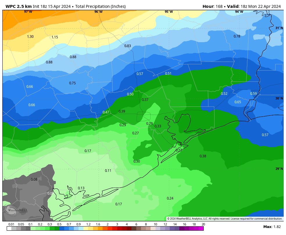
The forecast begins to change Saturday evening, or perhaps during the overnight hours. Showers and thunderstorms will mass to our northwest, with areas such as College Station at risk of 2 or more inches of rain, with higher bullseyes. How much of this heavier rainfall filters down into Houston is an open question, however. At this point I expect milder conditions in the city, and down to the coast, where accumulations of 0.25 to 0.75 inch of rain appear more likely. Thunderstorms will be possible, although less likely. Lows on Saturday night should drop into the mid-60s.

Sunday

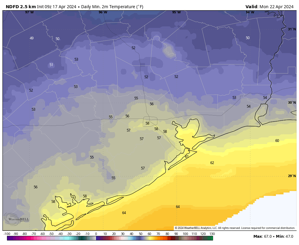
A chance of showers will linger in the morning, near the coast. But for the most part this should be a cloudy and cooler day, with highs in the lower 70s, and lower humidity. We’re going to get one fairly cool night with this front, and it comes Sunday night. Most of the city will drop into the 50s heading into Monday morning.

Low temperature forecast for Sunday night in Houston. (Weather Bell)

Next week

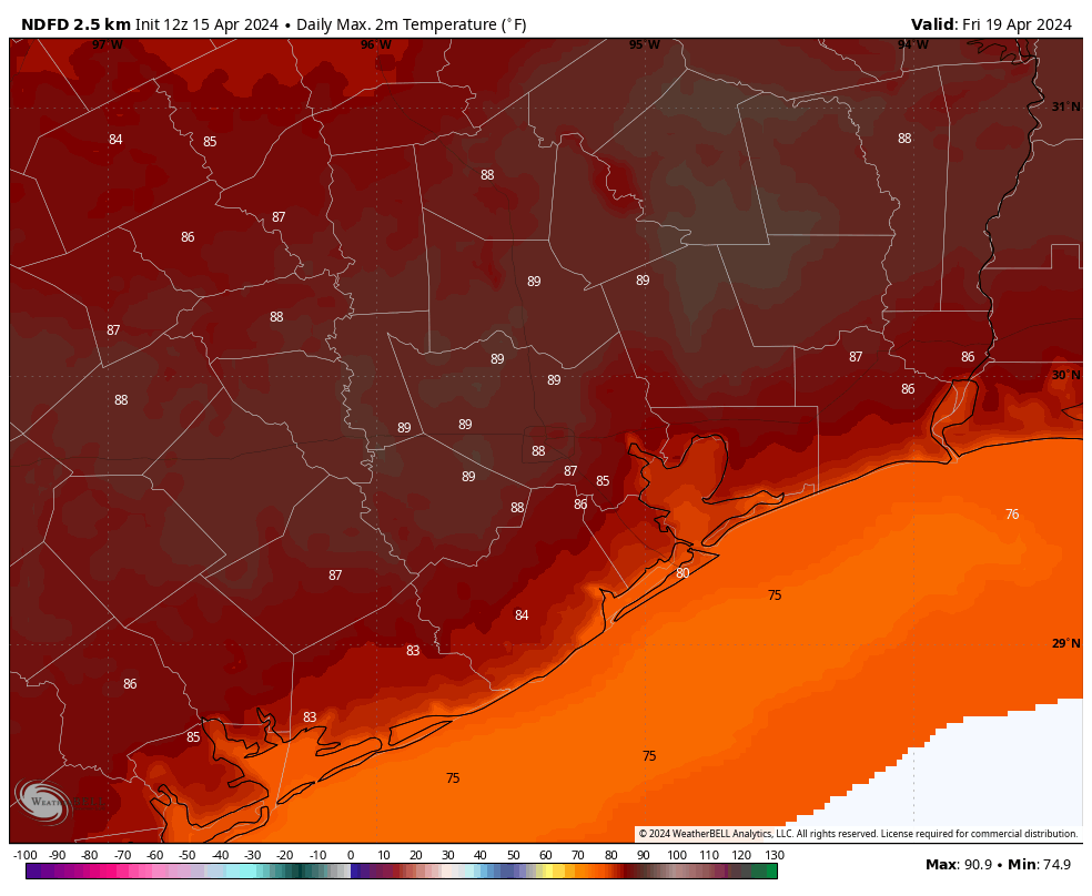
Monday should also see highs in the 70s before the onshore flow really starts ripping again. We’ll accordingly warm up, and will likely reach the mid-80s by mid-week, and upper-80s toward the end of next week. Highs potentially in the 90s are definitely in play, but we’ll have to see how things shake out.

We’ve got a couple of major outdoor athletic endeavors next weekend, the Texas Bike MS 150 and IRONMAN Texas event in The Woodlands. A precise forecast remains impossible, but the overall pattern looks warm and humid. I’m guessing highs in the upper 80s, with a fairly pronounced southerly wind. Rain chances, at this vantage point, continue to look fairly low.

Houston flirting with record warm nights as a humid pattern continues into the weekend

Summary: Our warm pattern continues, with humid days and sultry nights heading into the weekend. Then, with the approach of a front, we’ll see widespread showers and some thunderstorms. These will likely peak on Saturday night and Sunday morning before drier air starts to move in and we see a couple of cooler nights.

Wednesday

As I write this low temperatures outside are in the mid-70s for much of Houston, with a relative humidity of around 90 percent. That is not quite summer-like sticky, but it is definitely rather warm for April. The record high minimum temperature for today, April 17, is 74 degrees. The city’s official monitoring station briefly hit 74 degrees this morning, so it’s likely we’ll tie the record for warmest low temperature for today.

The warm and sticky weather will continue into the weekend. Highs today are likely to top out in the mid-80s, with mostly cloudy skies. Winds will be light, generally from the south at 10 mph or so with higher gusts. It will be another warm evening, but there is enough moisture about to potentially generate some light shower activity later this evening, perhaps after 9 pm, and into the wee hours on Thursday morning. Don’t expect much in the way of accumulations. Any showers are likely to be fairly scattered.

Friday will bring highs in the upper-80s to most of the Houston region. (Weather Bell)

Thursday and Friday

These will be a pair of warm and mostly cloudy days. Expect highs in the mid- to upper-80s with plenty of humidity, and southerly winds at about 10 mph with higher gusts. While there will be plenty of moisture in the atmosphere, a stout capping inversion will be in place that should limit rain chances to 10 or 20 percent each day. Nights remain warm, in the low- to mid-70s.

Saturday and Sunday

A cold front will approach the region this weekend, and eventually move through the area early on Sunday morning. This will determine our weather, and when and where we see rainfall. For now, I expect Saturday to see mostly cloudy skies, highs in the mid 80s, with scattered rain showers. Rain chances will increase on Saturday evening, and through the overnight hours, as the front nears and passes. At this point, rain chances look to be higher, along with a greater potential for heavy rainfall, for locations north of Interstate 10. There is, as yet, no strong signal for severe weather beyond typical thunderstorms.

Sunday will be cooler, with highs likely in the low 70s. Although some drier air will be moving in, some showers may linger near the coast in the morning. Skies should start to clear some during the afternoon hours. Lows on Sunday night will drop into the 50s for most of the area. This may be the only night in the 50s with this front, so enjoy the cooler and drier air.

There will be a decent chill in the air on Monday morning. (Weather Bell)

Next week

Monday will be another pleasant spring day with drier air, a fair amount of sunshine, and highs of perhaps 80 degrees. After that we’ll start to warm back up with a fair bit of humidity. Look for highs in the mid- to upper-80s during the second half of next week.

If you’re planning to participate in the Texas Bike MS 150, it’s still too early to have too much confidence in the forecast. There’s no strong indication of rainfall or storms, and the most likely outlook is fairly warm and humid weather. That would tend to imply a nice southerly or southeasterly breeze for the rides to La Grange and College Station, but I would be a fool to try and predict winds this far out.

Warmer weather continues, with the potential for some rain this weekend

Summary: Houston faces several warm and humid days before a front arrives this weekend to cool us down for a bit. The front is likely to bring some rain showers with it, which may impact plans you have for Saturday evening.

Tuesday

Conditions this morning are warm and overcast in Houston, and that’s more or less what we are going to see the remainder of the week with a persistent southerly flow. Skies will be partly to mostly cloudy later this afternoon, and high temperatures will push into the mid-80s. Winds will be fairly robust from the south, with gusts up to 25 mph in response to a front advancing across the stateā€”a front that will, alas, peter out before it reaches the greater Houston metro area. Lows tonight will drop into the low 70s in Houston.

Wednesday and Thursday

Expect more of the same. We’ll see mostly cloudy skies and highs, generally, in the mid-80s. A few spots could get warmer if we see some strategic breaks in the clouds during the afternoon hours. Winds will be from the south at about 10 mph, with gusts up to 20 mph. Nights remain warm and muggy.

High temperatures on Friday will likely be the warmest of the week. (Weather Bell)

Friday

This looks to be the warmest day of the week as skies may be only partly clouded over. This additional sunshine should help nudge daytime temperatures upward, into the upper 80s. A few locations in Houston, particularly to the west of downtown, may hit 90 degrees for the first time this year. With plenty of humidity, this will feel rather warm for mid-April. Overnight lows will continue to run about 10 degrees warmer than normal.

Saturday and Sunday

Saturday should see continued warm and cloudy weather, with highs in the mid-80s and plenty of humidity. However, during the afternoon and evening hours, rain chances will increase, peaking overnight as a front moves into Houston. At this time there is not a strong signal for severe weather to accompany the front, but we’ll continue to watch for this possibility, as spring-time storms are always possible in these kinds of situations.

NOAA rain accumulation forecast for now through Sunday. (Weather Bell)

In terms of accumulations, I don’t think the models have a great handle on things yet, but I’d expect most of the area to receive less than 1 inch of rain with the front. Sunday should see partly to mostly cloudy skies with highs in the 70s and lower humidity. Lows on Sunday night should drop into the upper 50s, or thereabouts, with the push of drier air.

Next week

Monday and Tuesday should be days with at least partly sunny skies and some drier air. So expect highs, perhaps, of around 80 degrees. After that a warmer and more humid pattern returns, with temperatures likely to return to the mid-80s or so.

This week’s weather will be consistently warm, humid, and mostly cloudy

Summary: After several days of sunny weather, a more southerly flow will take hold of Houston’s weather and that will bring us warm days and nights, mostly cloudy skies, and generally humid weather. This pattern of highs in the mid- to upper-80s will hold until the weekend, when a weak front is likely to move into the area, bringing showers with it.

Most of Texas, aside from the Panhandle, is starting the work week warm. (Weather Bell)

Monday

Highs today will max out in the low 80s, as the warm southwesterly flow that will bring warmer weather this week is not yet in place. But there will be plenty of moisture in the atmosphere and, accordingly, mostly cloudy skies. Winds will blow from the south at about 10 mph, with occasional gusts up to 20 mph. Lows tonight will drop only to around 70 degrees in Houston.

Tuesday

The area may see a few isolated to scattered showers early on Tuesday in association with a front that will die far to our west, but otherwise we’ll continue to see mostly cloudy skies. Highs will be in the mid-80s with a warm, southerly breeze.

Wednesday, Thursday, and Friday

These days will be warm. Skies will be partly to mostly cloudy, but if we get some breaks in the sunshine during the afternoon hours some locations could hit 90 degrees. For the most part, however, we’ll be in the mid- to upper-80s with plenty of humidity. Nights will be very warm for April as well, with lows only dropping into the low-70s. Rain chances are not non-existent, but they’re likely around 10 percent each day.

Friday may well be the hottest day of the week. (Weather Bell)

Saturday and Sunday

The weekend forecast remains in a bit of flux, depending on the timing of a weak front. My best guess is that Saturday brings partly sunny weather, with highs in the mid- to upper-80s, and that there’s a decent chance of rain Saturday evening or overnight ahead of the front. Rain chances linger on Sunday, with highs perhaps in the 70s and some modestly drier air. In a day or two we should be able to iron out some of these details.

Next week

After a couple of cooler days, and nights with lows perhaps around 60 degrees, we’ll probably be back in the mid-80s by the middle of next week.