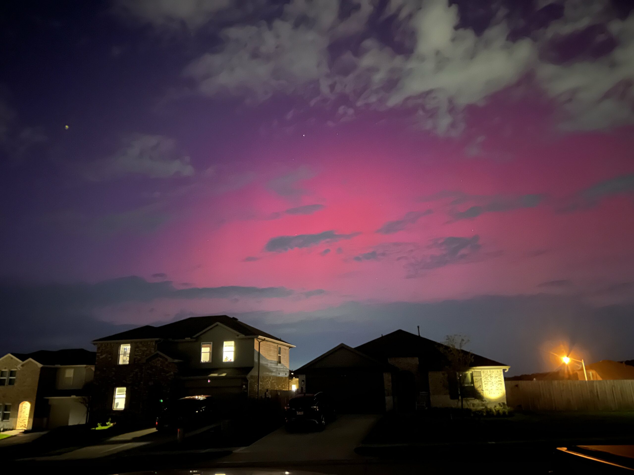
In brief: If you have clear skies and minimal light pollution, look to the north for a chance that you may see the aurora borealis (or northern lights) here in Southeast Texas.
We’ll keep this brief. A massive, if not historic solar storm has unleashed a barrage of solar flares toward Earth. Those arrived today, the strongest solar storm in at least 20 years to impact us. We have seen reports all over Europe of the aurora being visible. Not just visible…VISIBLE. Those reports have spread into the U.S. now, with much of Georgia, parts of Mississippi, Mobile, AL, and now Pinehurst and The Woodlands and Lake Conroe reporting the aurora.
The aurora can be fickle, so there is no guarantee you will see it everywhere tonight, certainly not in the city of Houston where light pollution is likely too much to overcome. However, if you have the means and time to get out and look north, this may be a once in a lifetime opportunity here in Southeast Texas. Please send us pictures as you’re able.
In brief: Quiet weather, (hopefully) less haze and smoke, and lower humidity will welcome us today and most of Saturday. Scattered to numerous showers and storms will bring a heavy rain chance back to the area on Sunday and Monday. We will be watching for flooding risks again to the north of Metro Houston.
I just want to start with a quick thank you to all that replied to our call for assistance earlier this week for our partners at the University of Houston working on weather messaging research. Nearly 200 of you responded, which is both amazing — and overwhelming! The small team of researchers at UH is working hard to get to everyone who replied. They should have more than enough response now to hopefully generate some interesting and useful results. Once again, you’re all awesome, so thank you!
Heavy rain update
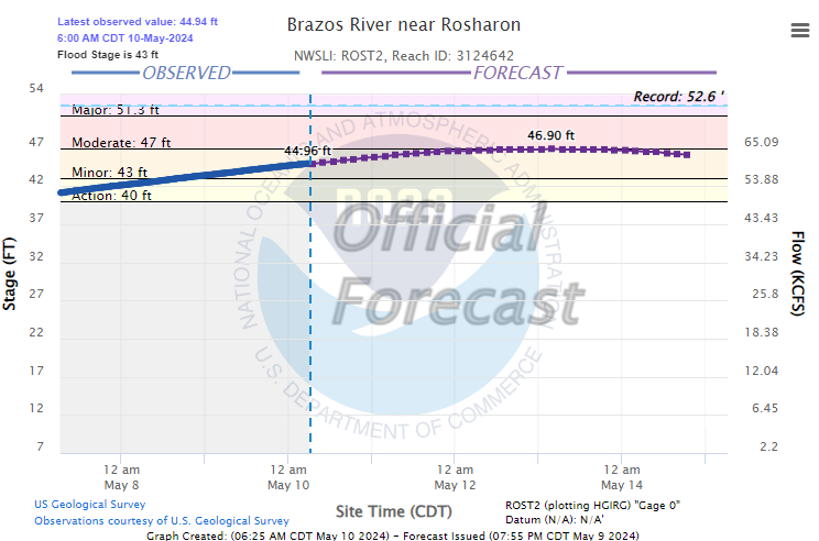
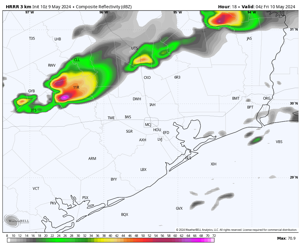
While most of Houston saw little to no rain last night, areas to the north and west were clobbered with large hail or heavy downpours. There was another 1 to 4 inches of rain on the northern end of Lake Livingston. At this point, it does not appear that will do much to the Trinity River situation (which continues to slowly drop). But we’ll await updated forecasts later today. Meanwhile, the Brazos will begin to crest from north to south this weekend into next week.
The Brazos at Rosharon is expected to crest early next week near moderate flood levels, which should contain most flooding to lowlands in Brazoria & Fort Bend Counties. (NOAA)
The crest should reach Rosharon by about Monday and then West Columbia by Tuesday, with minor to moderate flooding, which primarily affects the lowlands and perhaps a couple roads near the river. This is not currently expected to get worse.
Today
Update (10:05 AM): Some showers have developed across Wharton and Jackson Counties and will spread eastward through the morning. Brief heavy rain is possible, and a shower can’t be ruled out in Houston either.
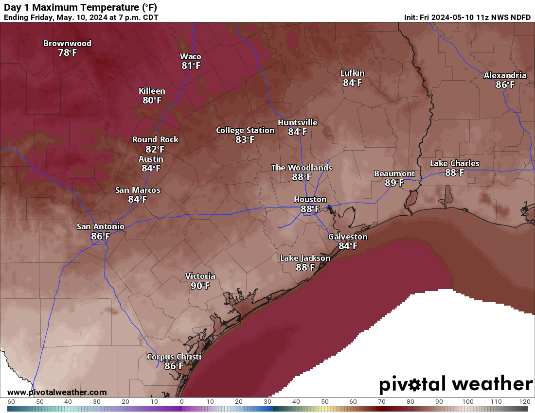
It seems plausible that some places will hit 90 degrees today thanks in part to lower humidity and clearer skies. (Pivotal Weather)
Will this end our streak of 90 degree-free days? Probably not. But it may be close. Drier air heats up more efficiently than humid air, and there may be just enough to push some of us over 90 today, particularly south of I-10. Maybe bet on Hobby Airport and not Bush Airport.
Saturday
This should be a mostly quiet day. Maybe a sprinkle or shower. But otherwise clouds, sun, still not terribly humid or hot. Morning lows will be in the 60s to near 70, with daytime highs in the mid-80s.
Mother’s Day & Monday
The word to your mother will be rain this year. Unfortunately we continue to see a soggy picture being painted for Sunday. I don’t think the entire day will be a washout everywhere, but an umbrella will be a required accessory for church or brunch or wherever your plans take you. Scattered to numerous showers and thunderstorms are likely on both Sunday and Monday. For the majority of metro Houston, most of the rain should be manageable. Some ponding or a stronger storm or two are possible. At this time, we don’t expect much worse than that. Again, that’s for most of Houston.
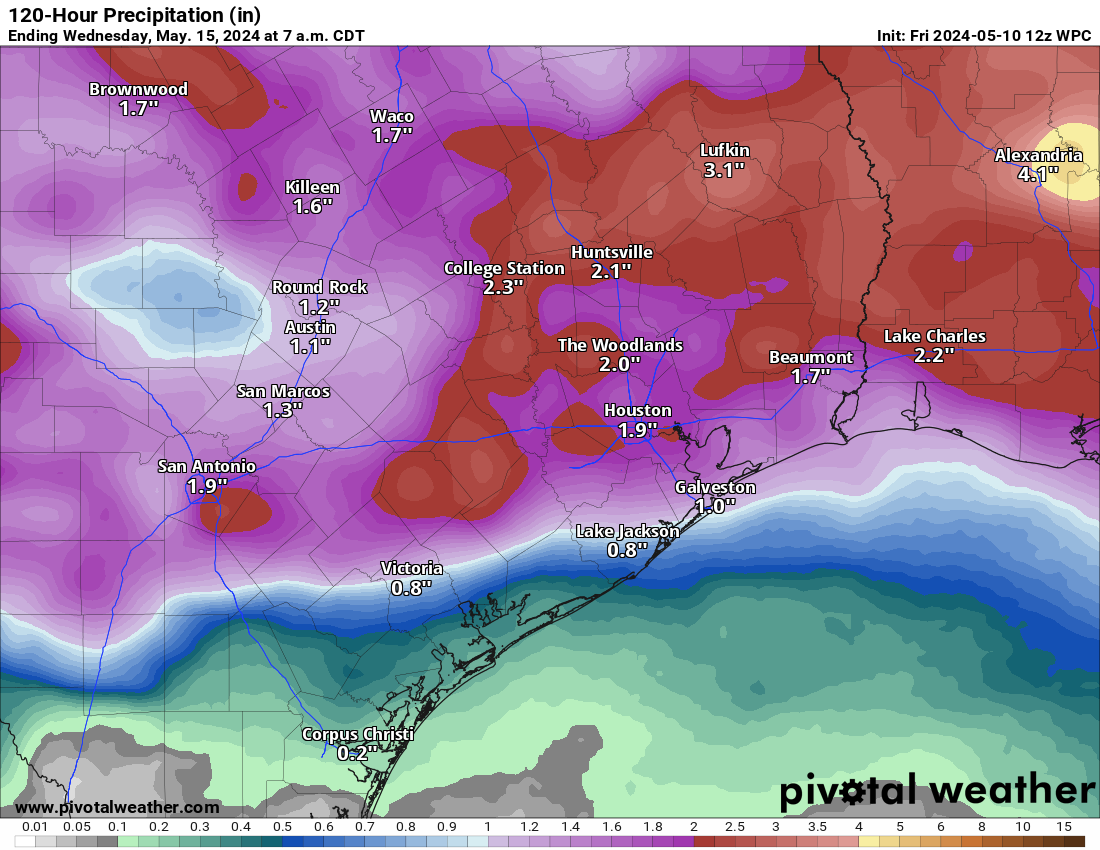
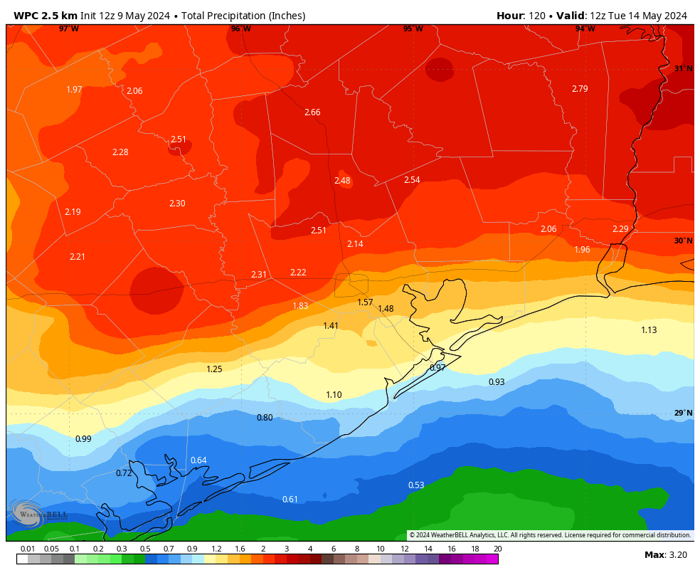
Rain totals of 1 to 3 inches are likely through Monday, with the highest totals probably north of Houston. Again. (Pivotal Weather)
That said, atmospheric moisture is near the top of the charts for this time of year, which means that we could be talking about heavy rainfall rates in spots. If those rains end up north of I-10 in vulnerable areas up in Montgomery, northeast Harris, or Liberty Counties and points north, we may have flooding issues again. For now, let’s call it 1 to 3 inches of additional rain, with lower amounts possible south and higher amounts possible north. Keep tabs on the forecast this weekend. We will have at least one more update later tomorrow or Sunday morning with the latest.
Rest of next week
Quieter weather should follow for Tuesday or Wednesday before more storm chances return perhaps Wednesday night or Thursday. We have an opportunity to hit 90 on Tuesday, but then our next realistic chance won’t come until next weekend.
In brief: There are several things to watch for in the forecast, including hot temperatures today, some isolated thunderstorms tonight, and the potential for rain on Sunday and Monday in the absence of high pressure. Also, if you enjoy dry air, then Friday night and Saturday morning will be your time to shine.
Thursday
Houston will experience one more warm and particularly humid day today before we cool off slightly. Whether temperatures hit 90 degrees today will depend partly on sky cover this afternoon, when skies should be partly to mostly cloudy. Winds will generally be light, from the southeast at 5 to 10 mph.
By this afternoon a front will be approaching the area, and this may serve as a trigger for some isolated thunderstorms later this evening. I think the most likely scenario is that these storms weaken before pushing into the Houston metro area, to the west of Katy and north of Tomball. However, there is a slight risk of development over Houston itself, in which case we may experience some briefly heavy rainfall and the potential for hail. So the risk is low, but non-zero this evening. Lows tonight should drop into the 70s in Houston.
The HRRR model forecast for 11 pm CT tonight shows the potential for isolated thunderstorms. (Weather Bell)
Friday
Drier air will slowly filter in to the region during the daytime on Friday, when I expect to see mostly sunny skies with highs in the mid- to upper-80s. Winds will be from the northwest at about 10 mph with some higher gusts. Lows on Friday night drop into the upper 60s to 70 degrees for most locations.
Saturday
The first half of the weekend looks fine, with partly sunny skies and highs in the low- to mid-80s. Dewpoints should reach their low point on Saturday morning, so if you’re someone who likes drier air, that will be a good time to be out and about. As you might know, Houston doesn’t get much (ok, any) of that during a typical June, July, or August. Lows will drop to about 70 degrees on Saturday night as the onshore flow returns.
Sunday
Mother’s Day won’t bring much sunshine, alas. In fact as high pressure exits the area, our atmosphere will open up to a series of disturbances that will bring decent rain chances through the middle of next week. For Sunday, this means scattered to widespread showers. There is a risk of heavy rainfall, particularly north of Interstate 10, but for the most part these should be reasonable rains I think. In any case, please consider the possibility of showers on Sunday as you make plans for mom. Highs will be about 80 degrees with returning humidity.
NOAA rain accumulation forecast for now through Monday. (Weather Bell)
Next week
We’ll see additional disturbances next week, and while the details are difficult to pin down, I expect to see a healthy chance of rain on Monday (highest), Tuesday (lowest), and Wednesday (medium) of next week. Regardless, it’s not going to be wall-to-wall rain, as there should be a fair amount of sunshine mixed in as well, with highs generally in the upper-80s. Rain chances diminish toward the end of the week, with highs likely around 90 degrees to go along with warm, humid nights.
In brief: Houston faces a couple of more warm-to-hot days before a weak front arrives to cool us down a bit. Saturday looks best for outdoor activities this weekend as rain chances increase in time to possibly put a damper on Mother’s Day in Houston. Also today, we invite you to participate in a University of Houston research project that will help us refine our flood scale. More information below.
Wednesday
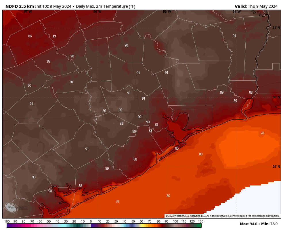
Houston narrowly missed 90 degrees on Tuesday, with a high of 88 degrees at Bush Intercontinental Airport. Today is likely to see similar temperatures, with highs in the upper 80s to about 90 degrees across most of the metro area. Partly to mostly cloudy skies should put a limit on temperatures beyond this. Winds will be from the south at 10 to 15 mph, with higher gusts. If you were out and about on Tuesday evening you may have noticed the humidity—that is what dewpoints in the mid-70s will do for you. Expect another warm and sultry night tonight.
High temperature forecast for Thursday. (Weather Bell)
Thursday
Another warm day. I think this will be the warmest of the week, with much of Houston likely reaching 90 degrees or a tick above. There may be a little more sunshine to help push temperatures up. If we look at the atmospheric profile, we see a fairly strong capping inversion that will help to prevent lift. However, if this cap breaks we could see some isolated showers and thunderstorms later on Thursday. Chances are probably less than 20 percent. Expect another warm night.
Friday
A weak front—there’s rarely any other kind this time of year, and we ought not to complain—will move through Houston on Friday morning. This will eventually bring some drier air into the region, but the day will start out fairly humid. Highs will likely reach the mid- to upper-80s beneath mostly sunny skies. Lows on Friday night will drop into the 60s for most locations, although how far will depend on your distance from the coast.
Saturday
The first half of the weekend looks splendid for mid-May. We’re talking partly sunny skies, with highs in the low- to mid-80s. The driest air will be found on Saturday morning, with dewpoints in the 50s. If you get out and walk, run, or bike that morning it should feel really comfortable. The onshore flow returns pretty quickly, however.
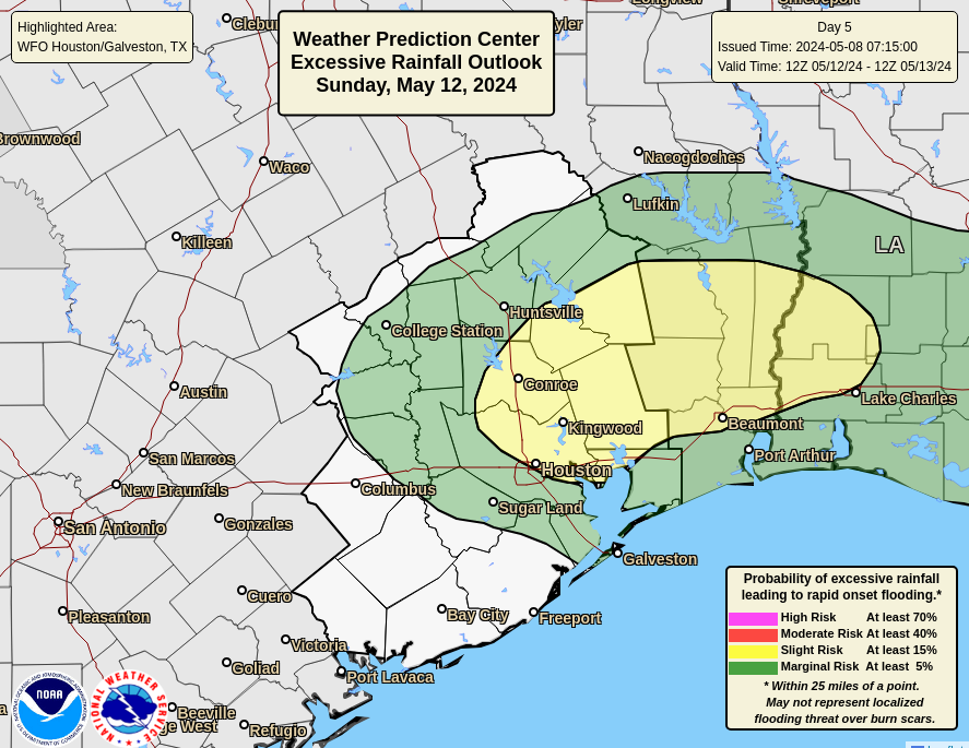
Excessive rain outlook for Sunday and Sunday night. (NOAA)
Sunday
Mother’s Day will have less sunshine, more humidity, and a decent chance of rain. Sorry, mom. Highs will likely top out in the low 80s. As high pressure moves away it will open up the region to a series of disturbances on Sunday and Monday. I don’t think we should be overly concerned about heavy rainfall, but the details are hard to parse at this point. It does look as though much of the area may see 1 to 2 inches of rain during the Sunday to Tuesday period. So expect scattered to widespread showers on Sunday.
Next week
More of the same is likely on Monday, with lesser rain chances later in the week. Highs next week look to return to the upper 80s or thereabouts. Humidity levels don’t look quite as high as we’re seeing at present.
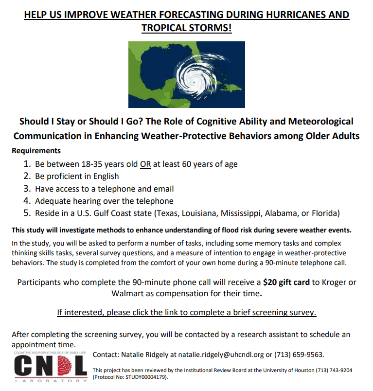
Help with flooding study
We are excited to announce a research partnership with the University of Houston! For our first project, we are trying to understand how people respond to different levels of flood risk during severe weather events. We are looking for people over the age of 60 or under the age of 35 to participate in a 90-minute, in-home telephone call during which they will complete some tests of thinking skills (e.g., memory), survey questions, and weather-related tasks. Participants who complete the study will receive a $20 gift card to either Walmart or Kroger. If you are interested in participating in this study, please click here.