In brief: The overall forecast looks more ominous, with atmospheric conditions favoring another round of strong showers and thunderstorms later today and tonight in the Houston region. We are instituting a Stage 1 flood alert for the entire area, and may possibly upgrade that to Stage 2 for areas north of the city later today.
Wednesday
Conditions this morning will be fairly calm, with only a smattering of light showers across the region. Highs today will reach the mid-80s, with mostly cloudy skies. Winds from the southeast will be a little higher, at about 10 mph, with gusts to 20 mph.
However, our confidence is increasing in another bout of fairly strong showers and thunderstorms later today or tonight. These storms will likely fire up late this morning, or during the early afternoon to the west of Houston and then move through this evening or during the overnight hours. I want to stress there is a fair amount of uncertainty in the timing and location of these storms, which will bring the potential of damaging winds and heavy rain. Given this uncertainty, we will likely post an update this afternoon to the website.
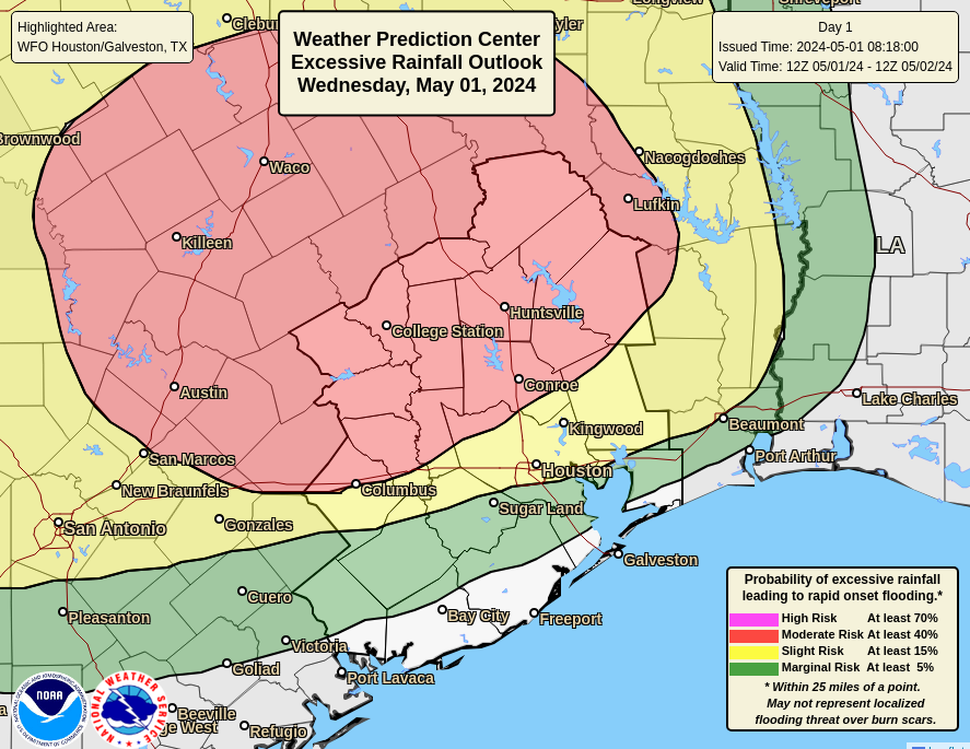
Outlook for excessive rainfall today and tonight. (NOAA)
At this time the greatest threat of heavy rainfall lies to the north of Interstate 10. However, some of the latest modeling and data point to a more widespread event that could bring heavy rainfall across the Houston metro area down to the coast. Regardless, I’m concerned about the potential for additional flooding along the East Fork of the San Jacinto River, which has already reached a major flood stage due to heavy rainfall earlier this week north of Houston.
In terms of rainfall accumulations, our model guidance is not at all consistent. Much of the area is likely to see an additional 1 to 3 inches of rainfall, but given the increasingly favorable setup for heavy rain I could see some locations picking up as much as 5 inches or more of rainfall tonight into Thursday morning. For now we are issuing a Stage 1 flood alert, which means nuisance street flooding mostly, for the entire Houston area. We may modify this later today.
Thursday
Rain chances will start to diminish during the morning hours on Thursday, but we’re likely to see some additional scattered showers throughout the day. Skies will again be mostly cloudy, with highs in the mid-80s. Lows Thursday night will be in the 70s—so fairly muggy and warm.
Friday
This will be another mostly cloudy day, with highs in the mid-80s and a chance of scattered showers and possibly a few thunderstorms. Rain chances should end at some point on Friday.
Saturday and Sunday
The weekend looks partly sunny and a bit warmer, with highs in the mid- to upper-80s depending on the extent of sunshine. Winds will be from the south-southeast, gusting up to 20 or 25 mph so there should be a breeze all weekend. With low to non-existent rain chances, the region will get a chance to dry out.
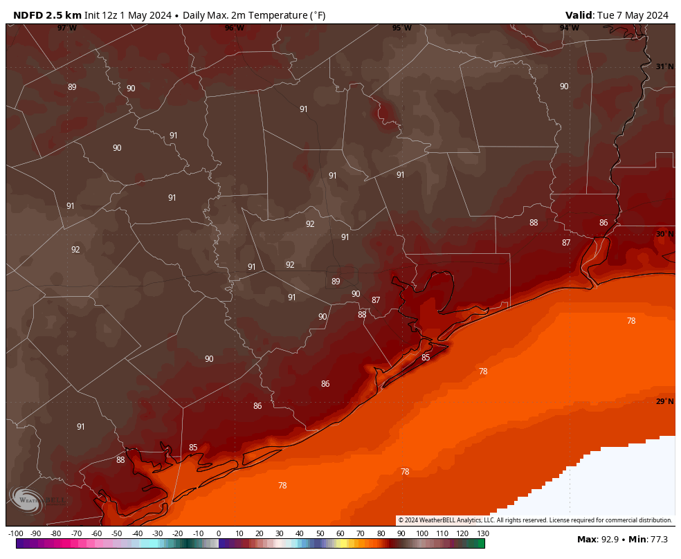
Some areas of Houston are likely to hit 90 degrees by Tuesday. (Weather Bell)
Next week
No changes in the forecast for next week as high pressure settles in. We can expect warmer weather, with highs likely reaching 90 degrees by Tuesday or Wednesday. The rest of the week looks warm and muggy with low rain chances. I’m hopeful that a weak front may arrive in time to cool us down slightly by next weekend, but that is something I certainly would not bet on.
Welcome to the “just in the nick of time” April edition of the SCW Q&A. Each month Eric and Matt tackle the most interesting questions you’ve thrown at them. You can leave more questions in the comments here, or hit the Feedback link in the blog’s sidebar. We’ll also scan our social media channels (Facebook, Instagram, Threads, X/Twitter, Mastodon, Bluesky) for queries. And we’ll try to get the Q&A posted sooner in May!
– Dwight
Q. Could this be is our last front until Sept/Oct? April is coming to a close soon, and I can’t recall many pronounced cooldowns in May.
A. Let’s get the bad news out of the way first. We are very near the end of the road when it comes to cool fronts in Houston. However, it is not unheard of to see cooler nights in May. That is not to say cold. If I squint into the distance, I can see a decent chance of a front around the May 11-13 period, so a little less than two weeks from now. That’s a long way out to have some confidence, but I’m modestly hopeful we may have one final fling with drier air before sultry summer settles upon us for months on end.
–Eric
Q. I had read before the event yesterday that clouds sometimes clear during an eclipse due to the cooldown. Is that what happened yesterday in Houston when we had a thinning of clouds enough to see the crescent?
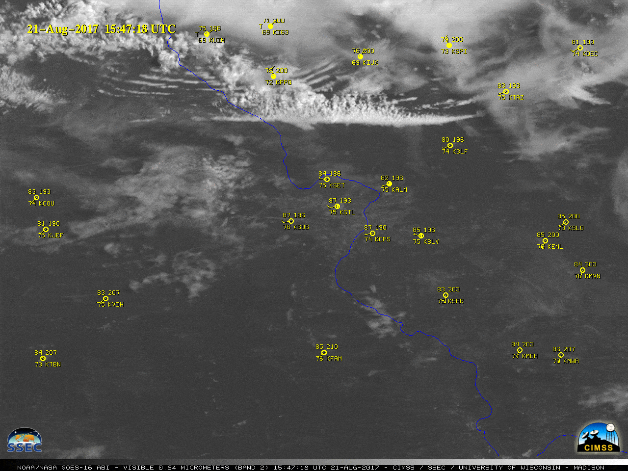
A. This is a great question. The answer is yes. During the eclipse in Houston, we had an issue with various sorts of clouds. We had higher level cirrus clouds, mid-level clouds, and low-level clouds. Most of the low-level clouds were cumulus clouds. What usually causes cumulus clouds to form? Heating. You heat the ground during the daytime, the heated air parcels rise, cool, condense, and you get clouds. Well, as you begin to block out the sun during an eclipse, you begin to reduce that heating mechanism. And in time, a lot of those cumulus clouds (or what we often call “fair weather clouds”) will dissipate. The animation below is from the 2017 eclipse, and you can see how the cumulus cloud field over Missouri and Illinois really dissipated as the eclipse unfolded.
A satellite loop of the 2017 total eclipse over Missouri and Illinois. (University of Wisconsin CIMSS)
This is likely what “saved” much of Texas this year. There were still plenty of clouds higher up, which are less impacted by daytime heating and more driven by physical storm systems. But by virtually eliminating a layer of lower cumulus clouds, you had one less obstruction to view the sun, which periodically broke through the higher clouds.
–Matt
Q. How far inland would you recommend having hurricane shutters to board up if a storm comes inland? I find myself trying to calculate what would be the strongest type of hurricane that we could feel in order to decide if I want to invest in shutters, but can’t find any info. Would you guys know?
A. We’re not storm damage experts, but whether you should have hurricane shutters depends upon several factors. First of all, the most important factor is whether you’re close to the coast, as winds do die down significantly as a storm moves inland and encounters friction with trees, homes, high rises, and other structures.. The second factor is the proximity of stuff, like trees and unattended deck chairs and you name it. The most common reason windows break is due to flying debris. So if there’s lots of things around that you can imagine flying into your windows, that’s a risk factor.
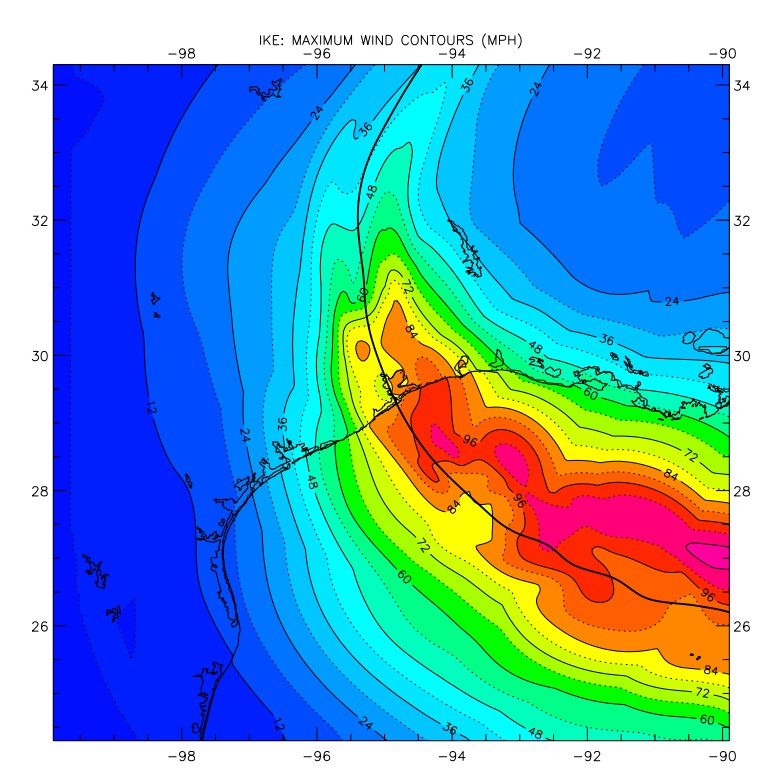
Maximum sustained winds from Hurricane Ike in 2008. (NOAA)
I’ll be honest with you. I’ve lived through flood storms in Houston. I’ve lived through surge storms. But I’ve not really experienced a wind storm. Hurricane Ike was the closest thing, but it barely brought Category 1 winds to parts of Houston. This was bad enough, knocking power out to the city for up to two weeks. At the time I lived in Clear Lake and we had to get a new roof. I guess what I’m saying is that it’s not just your windows, it’s also your roof. And a prolonged period without power.
I guess what I would advise is that, if you live south of Interstate 10, and can afford it, hurricane shutters are not a bad idea. You will probably never need them, but if it proves peace of mind, that is not a bad investment in an uncertain world. Make sure they’re easy to put up on short notice.
–Eric
Q.On your weather app I notice that the humidity (sorry I mean HOUmidity) can be low in the evening and then go way up in the morning, coming back down again as the day goes on. Why?
A. Relative humidity (RH) is just that, relative. Dewpoint temperature is the temperature to which you’d need to cool the air to saturate it. In other words, the higher the dewpoint, the damper the air is. Dewpoint can fluctuate, but it’s usually more stable than temperature. So, let’s say you have a dewpoint of 72°. The morning low is 75° in this example. That means your morning relative humidity at 75/72 would be 90 percent. Obviously, you warm up during the day, so with a high of 88 degrees but a steady dewpoint still sitting at 72, your RH at 88/72 has dropped to 59 percent. As the air cools around sunset bringing the temperature relatively closer to the dewpoint, the humidity rises again. It limits the usefulness of RH. This is why we flout other metrics like dewpoint to drive home how humid it actually feels.
–Matt
Q. After your earlier answer, I’m confused by the description of what “percent chance of rain” represents. I was taught in my meteorology classes that probability of precipitation in weather forecasts means the probabilistic chance that it will rain at the point specified in a given time period. For example, if I enter my zip code to get a National Weather Service forecast for my area today, a 40 percent chance of rain means each point within my zip code has a 40 percent chance of seeing rain, not that 40 percent of the land area within my zip has a chance of seeing rain. Insights? Or is this just splitting hairs?
A. It’s more or less splitting hairs. But this is a fun topic so why don’t we dive a little deeper. Let’s go directly to the National Weather Service, where we find this delightful introduction to its “probability of precipitation” explainer:
The probability of precipitation forecast is one of the most least understood elements of the weather forecast.
I just love the “most least” phrasing. A perfectly confusing introduction to a confusing topic. Anyway, fundamentally you are correct that it is a point forecast rather than an areal forecast. But it is a point forecast based on an areal forecast. If that makes sense. Which it probably doesn’t. And that’s ok.
There are two factors that go into making a “probability of precipitation” forecast. First there is the forecaster’s certainty that precipitation will form or move into the area, and this is multiplied by the areal coverage of the precipitation that is expected. Here are two examples for how one might derive a 40 percent chance of rain:
(1) If the forecaster was 80 percent certain that rain would develop but only expected to cover 50% of the forecast area, then the forecast would read “a 40 percent chance of rain” for any given location.
(2) If the forecaster expected a widespread area of precipitation with 100 percent coverage to approach, but he/she was only 40 percent certain that it would reach the forecast area, this would, as well, result in a “40 percent chance of rain” at any given location in the forecast area.
Does that clear things up? Probably not.
But given the general inaccuracy of precipitation forecasts, I think it’s fine to think of a “40 percent chance of rain” as either a point forecast or, more generally, that about 40 percent of an area will receive rainfall during a given period of time. This is not an exact science, it’s just a forecaster making a most best guess of things.
In brief: Expect another mild day today before decent rain chances return Wednesday through the end of the work week. These are likely to be garden-variety showers rather than anything too intense or organized. The weekend looks warmer and sunnier, and after that the story will become one of increasingly hot temperatures.
Tuesday
Today will see rather mild conditions. Expect highs, generally, in the mid-80s. Skies will be partly sunny for much of the day, with relatively light south-southeasterly winds. A few scattered to isolated showers will be possible, but most of the region should remain dry. Lows tonight will be a few degrees warmer, likely dropping only into the low 70s.
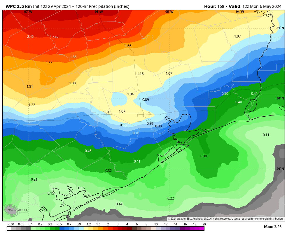
NOAA rain accumulation forecast for now through Friday. (Weather Bell)
Wednesday, Thursday, and Friday
The latter half of the work week will turn more unsettled, as a series of disturbances pass overhead. At this point I can’t pinpoint which of these three days will have the best rain chances, but daily odds are likely on the order of 30 to 50 percent. We are not looking at anything too crazy, with accumulations of 1 inch or less likely for most of the region.
Skies each day will bring a mix of clouds and sunshine, although clouds are likely to be more the norm during the morning, with a better chance of some sun breaking through during the afternoon hours. Highs will generally slot into the mid-80s, with warm and humid nights. Winds will be from the southeast, generally, with some occasionally gusty conditions.
Saturday and Sunday
The weekend looks sunnier and warmer, with highs in the mid- to upper 80s. Rain chances should slacken this weekend as high pressure begins to take hold, but I can’t rule out a few stray showers. That will have implications for our weather next week.
Here comes the heat. (Weather Bell)
Next week
And those implications, as you might guess, are such that we’ll see warm if not hot conditions. As high pressure builds we are likely to see our first 90-degree readings of the year by Tuesday or so of next week. Lows will only drop into the mid-70s. High pressure should also shut down rain chances for most of next week as well. Summer, one might say, is coming…
In brief: We discuss heavy rainfall north of Houston, and lesser accumulations in Houston. After this morning we’ll see a reprieve from showers, but starting Tuesday or Wednesday we’ll see decent chances for the remainder of the week. The weekend should see clearing skies and warmer temperatures, so the early beach outlook is favorable.
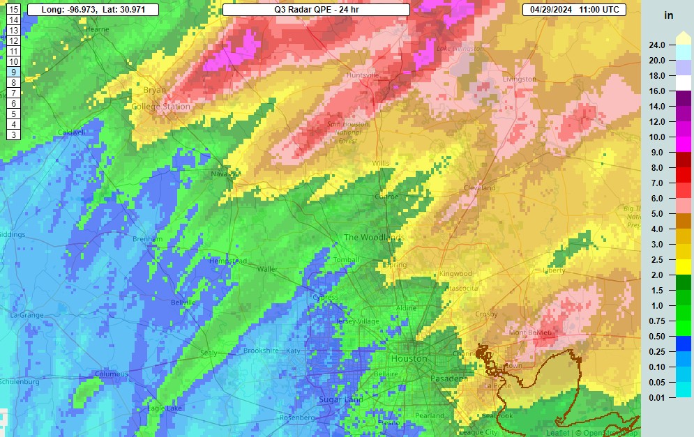
The boundary that produced significant rainfall overnight is exiting the area, but it has done its damage in terms of heavy rainfall to the north of Houston. Two areas, one from College Station to Madisonville, and another northeast of Huntsville, recorded 10 inches of rainfall during the last 24 hours. Some rivers and bayous in this area are likely to reach a moderate flood stage over the next day or so.
Rainfall totals during the last 24 hours north of Houston. (NOAA)
Closer to Houston, the high-water mark came near Baytown and Mont Belvieu, with a few areas recording 5 to 7 inches. Rainfall amounts were widely variable, as some areas of just west of Houston picked up less than half an inch. But all in all it was a wet night. Too wet for some areas, with ongoing flooding occurring north of Houston, but still some much-needed rain for most locations. The remainder of spring should be nice and green in our region.
Monday
The line of storms has moved well to the east of Houston this morning, but we’re seeing some lingering showers, and these could continue for coastal areas through the morning hours. Later today we’ll see clearing skies, and this is likely to be our best chance for guaranteed sunshine this week, at least until the weekend. One welcome change this morning is much lighter winds, which will blow today from the east-southeast at 5 to 10 mph. Highs will reach into the mid-80s, with a few locations popping into the upper-80s depending on sunshine. Rain chances remain low this evening and overnight, with temperatures dropping to around 70 degrees in Houston.
Tuesday and Wednesday
The overall pattern remains unsettled this week, with the absence of a strong high pressure system. As a result we’ll see continued decent rain chances, on the order of 30 percent daily. I don’t expect anything too organized, and for the most part these should be scattered, garden-variety showers. Highs both days will be in the low- to mid-80s with mostly cloudy skies. Nights will be warm, in the low 70s.
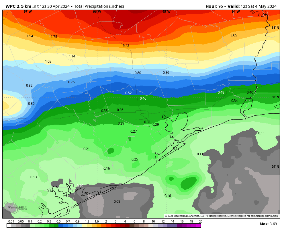
Rain accumulation forecast for later this week. I’m a bit concerned about rain totals for areas near College Station and Huntsville later this week. (Weather Bell)
Thursday and Friday
We’ll see a continued partly to mostly cloudy pattern to end the work week, but rain chances will inch up a bit. Again, I’m not expecting a deluge, but daily rain chances will likely be on the order of 40 to 50 percent. Accumulations should be greatest north of Houston. Look for highs in the mid-80s, depending on how much sunshine breaks through during the afternoon hours. Southerly winds will pick up a bit toward the end of the week, with some gusts of 20 or 25 mph possible.
Saturday and Sunday
Rain chances should diminish some this weekend, with a corresponding increase in sunshine. We’ll still see some clouds, but there probably will be more blue skies, and there appears to be only a slight chance of rain at this point. Look for highs in the 80s, perhaps upper 80s, with plenty of humidity to spare. All in all, a good pool or beach weekend for early May.
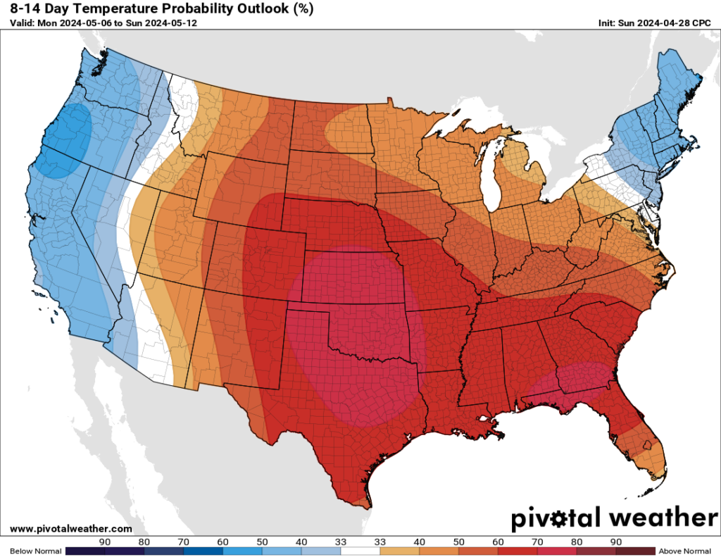
Next week looks rather warm for Texas, in early May. (Pivotal Weather)
Next week
Could we see our first temperatures in the 90s next week? Quite possibly. The first full week of May looks fairly sunny, and fairly warm. We could see the onset of summer lite in Houston if current trends hold.