Is this Houston’s last night in the 50s for at least five months?

In brief: Houston may be experiencing its last truly chilly night until next fall. (That was painful to type). After this we’ll be transitioning to warmer weather, with temperatures eventually reaching the upper 80s this weekend, with a persistent southerly wind. Rain chances increase a bit on Sunday, and a little more on Monday.

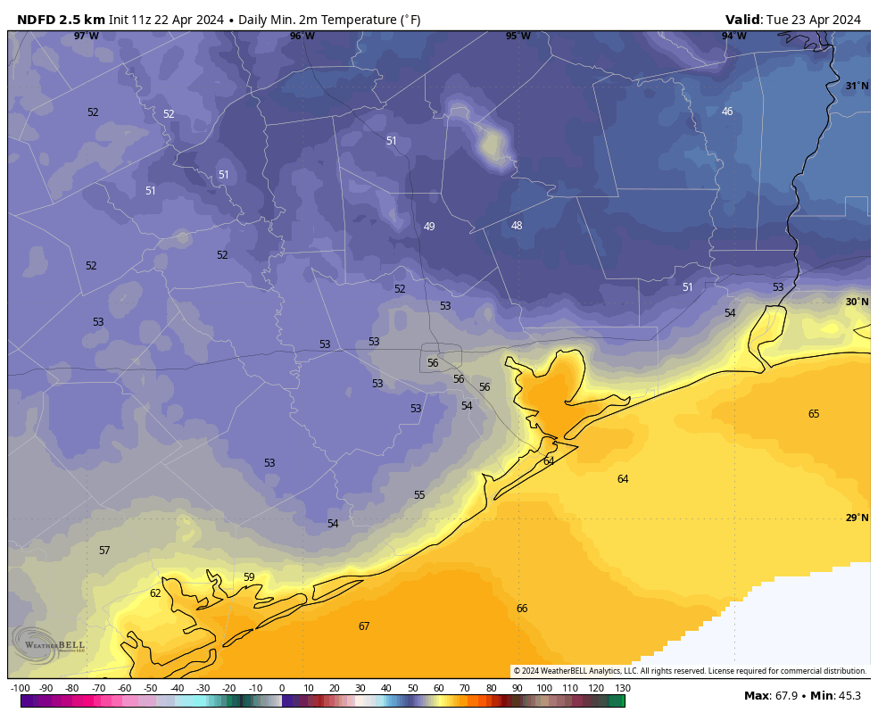
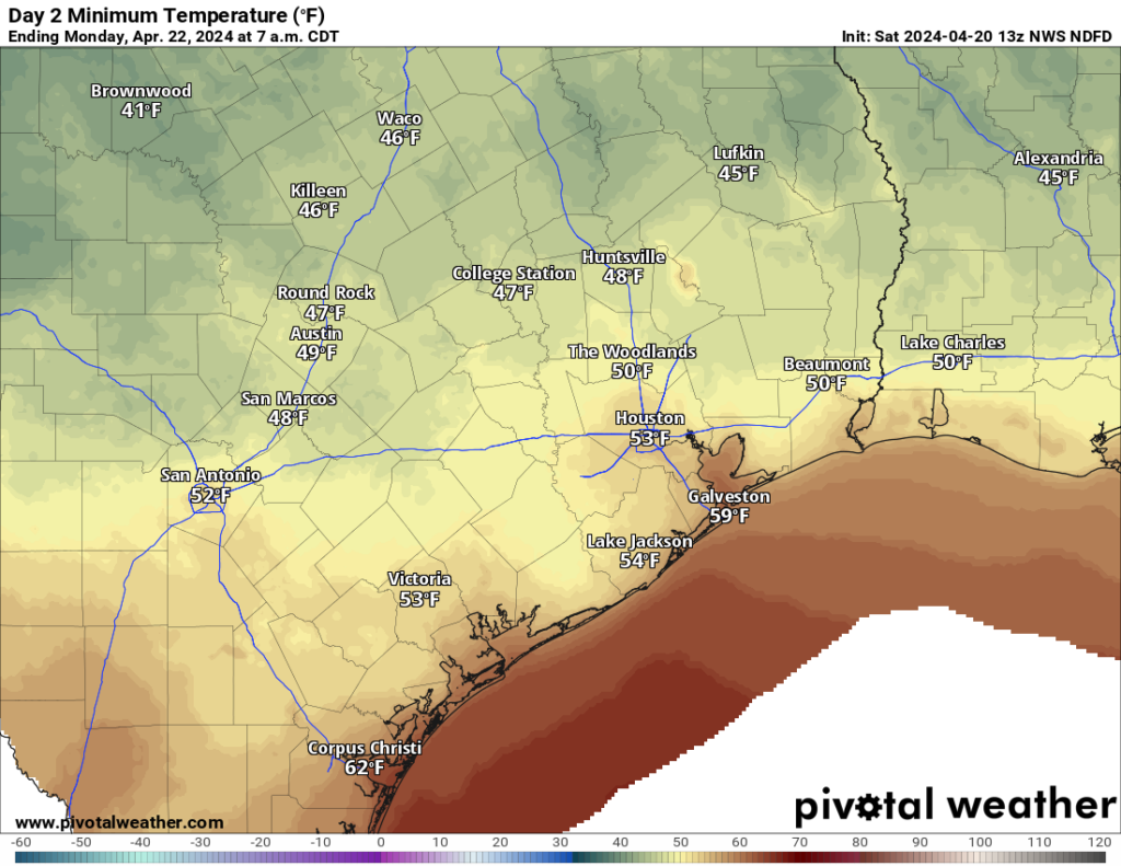
Final night in the 50s?

This is not a firm prediction, but rather an informed guess. Temperatures this morning are in the 50s across Houston, with even a few spots in the 40s, such as Conroe and Cleveland. But alas, this could be our final fling with such cooler weather. In fact, it would not surprise me if we do not see another chilly night like this for five or more months.

It is pleasantly cool this morning across much of Texas. But summer is coming. (Weather Bell)

Why is that? We certainly can see cooler nights in May, before the real onset of summer. But lows in the 70s are much more common in May than lows in the 50s. Last year, Houston saw its final springtime night in the 50s on May 1. We did not touch the 50s again until October 8. This year I don’t see any evidence of a cooler night during the next 10 days, at least. Hopefully we won’t have to wait all the way until October again.

Tuesday

Winds are now firmly coming from the south, but it will take some time to replace the drier air mass that has been in place since Sunday. Accordingly, we’ll see a mix of sunshine and clouds today, with highs in the upper 70s to 80 degrees. Moisture levels will rise, and by this evening it will start to feel fairly humid. Winds will be light, generally only 5 to 10 mph, from the south-southeast. Lows tonight will only drop into the upper 60s.

Wednesday

Temperatures will be a bit warmer, in the low 80s, with a bit more humidity. I think skies will mostly clear out in the afternoon, allowing for a fair bit of sunshine. Overnight lows will only drop to about 70 degrees.

Thursday and Friday

Windy and warmer. Both days should see highs somewhere in the mid-80s, but the bigger story is likely to be increasing onshore winds. They’ll blow from the south at about 10 to 15 mph, with gusts up to 25 mph on Thursday, and perhaps 30 mph on Friday.
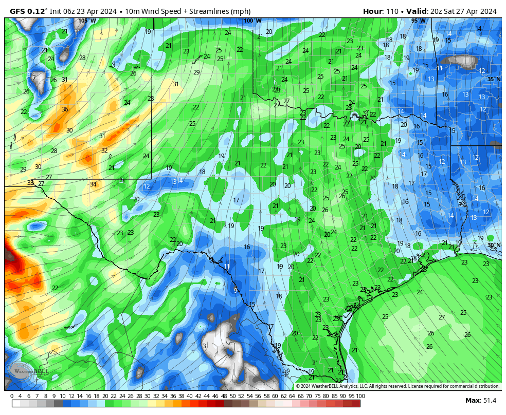
Sustained winds on Saturday will be 20 mph from the south-southeast, with higher gusts. (Weather Bell)

Saturday and Sunday

The weekend should be even a bit warmer, with highs pushing into the upper 80s, with partly to mostly sunny skies. The other story will be continued breezy conditions. Winds look to peak from the south-southeast on Saturday, gusting to 35 mph, but we still could see gusty conditions on Sunday. This should provide a pretty epic tail, or cross-tailwind for Texas Bike MS 150 riders this weekend. One thing to watch for on Sunday, especially for the aforementioned bike riders, is some showers to the northwest of the Houston area, generally north of the The Woodlands, and west of Katy. Rain chances in Houston itself, on Sunday, are lower and probably on the order of 20 percent.

Next week

The forecast models diverge in terms of their solutions for next week. The GFS model keeps us in the upper 80s, with only scattered showers. The European model is a little bit cooler with better rain chances area-wide. As we’ll be in want of some rain by then, I’m hoping for the latter solution. We shall see.

Today will be one of the very nicest days of the year. And after that? Well…

In brief: Monday will yield an absolutely splendid day of weather in Houston. Like, it will be one of the top 10 nicest days of the year. Tuesday will also see a modicum of drier air before a warmer, southerly flow takes ahold. The weekend will see highs in the upper 80s with strong southerly winds, but rain chances will probably hold off until at least next Monday.

Monday

Do you like dry air, mild temperatures, clear skies, and light winds? Because today checks all of those boxes. After a pleasantly cool start in the 50s, temperatures will reach the lower- to mid-70s this afternoon with light winds. Skies should be mostly sunny, albeit with a few clouds this afternoon. With dewpoints in the 40s, the air will feel plenty dry.

In my humble opinion, this is just about the finest weather one could have—but such things never last. Those light northeast winds will shift to come from the southeast later today, and while we won’t feel the influence of that right away, it will set into motion a prolonged period of a southerly flow, and set the stage for a much warmer pattern later this week. Lows will still get into the mid-50s tonight in Houston, with cooler conditions inland.

Houston will see one more cool-ish night on Monday night. (Weather Bell)

Tuesday

This will be a bit of a transition day, as humid air begins to replace dry air, but the swap is not yet complete. Skies will be mostly sunny, with highs near 80 degrees. Winds will be from the south at 5 to 10 mph. With the influence of the southerly flow, lows on Tuesday night will be considerably warmer, in the mid- to upper-60s.

Wednesday, Thursday, and Friday

This will be a trio of modestly warm days, with highs in the low- to mid-80s. We’ll see a mix of sunshine and clouds each day, although each successive day should see more cloud cover and less clear sky. Nights will drop to around 70 degrees, give or take, with decent amount of humidity. Winds will consistently blow from the south, increasing in velocity toward the end of the week when we may see sustained winds of 20 mph, with gusts of 30 mph.

The period of Saturday through the middle of next week looks warmer for the Southern United States. (Pivotal Weather)

Saturday and Sunday

Those winds will persist into the weekend. We’ll see this deepening southerly flow over the region due to a potent low pressure system over the central United States. This gives us a fair amount of confidence in the forecast for this weekend, and it’s a warm and windy one. If you’re participating in the Texas Bike MS 150 (Saturday and Sunday) or IRONMAN Texas event (Saturday), you can expect temperatures in the upper-80s, generally. Skies should be partly sunny. Both days will see strong south-southeasterly winds, blowing at perhaps 20 mph, with gusts up to 30 mph—so generally a pretty amazing tail wind for bike riders. Rain chances also look low, to non-existent through most of the weekend.

Next week

By Monday we may begin to see something of a pattern change, with slightly better rain chances entering the forecast. While I can’t rule out some kind of front working its way into Houston, right now the most likely scenario is continued warm weather in the upper 80s for much of next week.

Flash flooding a good possibility in some spots northwest of Houston later today

Summary: We are hoisting a Stage 1 flood alert for areas northwest of Houston that should see heavy rain later today. Street flooding is a good bet in those areas. Houston and points south and east will see substantially less rainfall. Things quiet down and cool down tomorrow.

Good morning! We covered the forecast mostly fine yesterday, but now that things are in focus, we can fine tune some details for you for today. First off, we are going to issue a Stage 1 flood alert on our Flood Scale for areas northwest of Houston. This means that we expect street flooding in spots, and it’s possible that we see some decent rises on some of the creeks or rivers in those areas. We could see enough rain to impact the Spring or Cypress Creek watersheds, among some others with rises or minor flooding. Also, the larger river systems north or northwest of Houston (Brazos, San Jacinto, Trinity) could see some decent rises.

We have established a stage 1 flood alert, meaning street flooding is possible to likely in spots for areas northwest of Houston. Flooding is unlikely south and east of Houston, and there will be an extremely sharp cutoff in rain totals. (Pivotal Weather)

Unique about this particular setup: Areas south and east of Houston may see minimal rainfall. Some places may even see no rain at all.

Here are a few more notes about this event.

Timing: There are already a few showers south of Victoria moving toward Matagorda, and through early afternoon a handful of isolated showers are possible. Most folks will be fine though. Between about 2 and 6 PM, we expect more isolated showers or storms anywhere in the area, eventually focusing northwest of Houston by evening in the areas of concern noted above. If you’re attending the Dynamo game this evening, I’m not too worried, but don’t be entirely shocked if it rains a bit or there is a brief lightning delay at some point. The worst rains north and west of Houston will be from about 6 PM through midnight, with everything eventually getting pushed east overnight and out of the area by morning. Some clouds or light rain will be possible Sunday morning.

Rain totals: You can see the forecast above, but there are risks. Houston and points south and east will see an inch or less, probably less than a half-inch in most spots. As you progress north and west from Downtown Houston, we should quickly see totals of 1 to 3 inches. In extreme northwest Harris County, Montgomery County, portions of Waller County, and north of there, expect 2 to 4 inches. A few locations in those areas will likely see 4 to 7 inches of rain, if not a bit more. This is where we are most concerned with flooding.

An NWS Houston graphic laying out the risk of flooding and higher rain totals northwest of Houston tonight. (NWS Houston)

Again, there will likely be a sharp cutoff between 1 to 2 inch rains and minimal rain somewhere in the Houston area.

And Sunday? Cooler! Look for breezy conditions and temperatures stuck in the 60s for most of tomorrow. Some light rain or a few showers may linger in the morning, with gradual PM clearing. Overnight lows into Monday morning still look to be in the 40s and 50s.

Monday morning lows will probably require a light jacket! (Pivotal Weather)

Should anything serious change, we’ll update you later. Otherwise, just stay safe and make sure you stay weather aware, especially northwest of Houston later today.

Pleasant weather is in sight for a couple days, but first Houston must deal with some rain and storms this weekend

Summary: Cooler weather is in sight as we head later into the weekend. Before that, it will be warm to hot and humid, and there will likely be heavy rain and strong storms north and northwest of Houston on Saturday evening. If you’re traveling north and west toward Austin, Waco, or Dallas Saturday afternoon or evening, use caution.

Today

We hit 88 degrees yesterday in what felt like an early summer preview. Expect more of the same today, though we could shave a couple degrees off yesterday’s temperatures with more clouds possible. An isolated shower or storm is possible, much like we saw yesterday across the area. This would be most likely in the afternoon hours.

Saturday into Sunday

The forecast gets more interesting here. As of now, Saturday morning looks warm, humid, but otherwise fine. An isolated shower or storm is possible from late morning into early afternoon. By mid to late afternoon, storm coverage should increase. Here’s how we expect it to go right now.

Storms could develop in the Houston area, along and north or west of US-59/I-69 after 2 to 3 PM. I suspect those storms will lift north and west a bit and eventually line up robustly between about College Station and Huntsville. There is some signal within the models of training storms up that way, so rain could continue to repetitively cycle over the same areas a bit. Eventually, as the front plows south and east, all of those storms will come with it. That should sweep back through the Greater Houston area between midnight and 5 AM or so. It will continue to progress east and out of our area on Sunday.

Rain totals will vary this weekend, with the highest amounts likely north and northwest of Houston, where as much as 3 to 5 inches could fall, leading to some flash flooding. (Pivotal Weather)

How much rain? I think we’re going to see a lot of variability, truthfully. From Houston south and east, probably a half-inch or less, unless the overnight storms pack more punch than we currently expect. Within Houston and the immediate suburbs north and west (Katy through Cypress and The Woodlands), we will probably see anywhere from a quarter-inch to an inch or more in an isolated spot or two. Farther north and west, along a line from about La Grange through College Station through Huntsville, rain totals will likely average 1 to 3 inches, and I would not be the least bit shocked to see someone end up with 5 inches or even a little more out of this. Flash flooding is a definite possibility up that way, and if you’re traveling between Houston and Dallas, Waco, or Austin tomorrow afternoon or evening, just be aware of this potential.

On Sunday afternoon, things should clear out, and the humidity will take a plunge.

Saturday’s highs will again be in the 80s, with morning lows in the 70s. Temperatures should drop into the 60s with the storms Sunday morning before recovering back to near 70 degrees in the afternoon. It will be noticeably cooler and breezy.

Next week

Monday looks absolutely spectacular for late April. Expect lows in the 50s (or even a handful of 40s!), highs in the low to mid-70s, and plentiful sunshine.

Monday morning will be one of our last truly cool mornings until autumn. (Pivotal Weather)

Tuesday should be similar humidity-wise but a touch warmer with lows near 60 and highs around 80 or a little hotter. The weather pattern may get a bit more unsettled for late week. Along with very warm highs well into the 80s to perhaps near 90 later next week, each day will have a slight chance of showers or thunderstorms. Details are still TBD. I don’t want to speculate a ton on next weekend yet, with plenty of big athletic events on tap. I don’t think the MS 150 riders will be enduring much of a headwind, but the rest of the forecast is up in the air. More to come.