Sorry mom, rain showers may spoil the party on Sunday

In brief: Houston faces a couple of more warm-to-hot days before a weak front arrives to cool us down a bit. Saturday looks best for outdoor activities this weekend as rain chances increase in time to possibly put a damper on Mother’s Day in Houston. Also today, we invite you to participate in a University of Houston research project that will help us refine our flood scale. More information below.

Wednesday

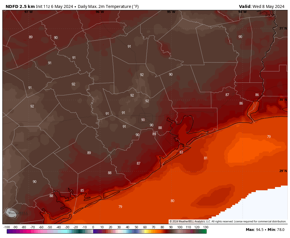
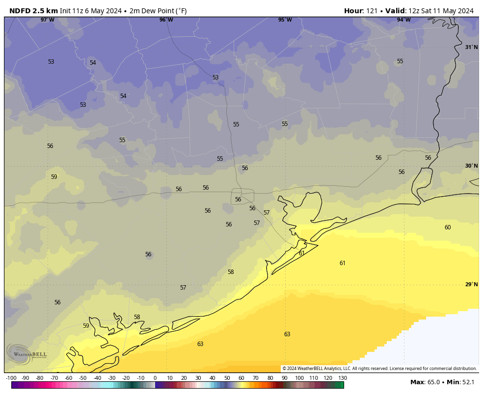
Houston narrowly missed 90 degrees on Tuesday, with a high of 88 degrees at Bush Intercontinental Airport. Today is likely to see similar temperatures, with highs in the upper 80s to about 90 degrees across most of the metro area. Partly to mostly cloudy skies should put a limit on temperatures beyond this. Winds will be from the south at 10 to 15 mph, with higher gusts. If you were out and about on Tuesday evening you may have noticed the humidity—that is what dewpoints in the mid-70s will do for you. Expect another warm and sultry night tonight.

High temperature forecast for Thursday. (Weather Bell)

Thursday

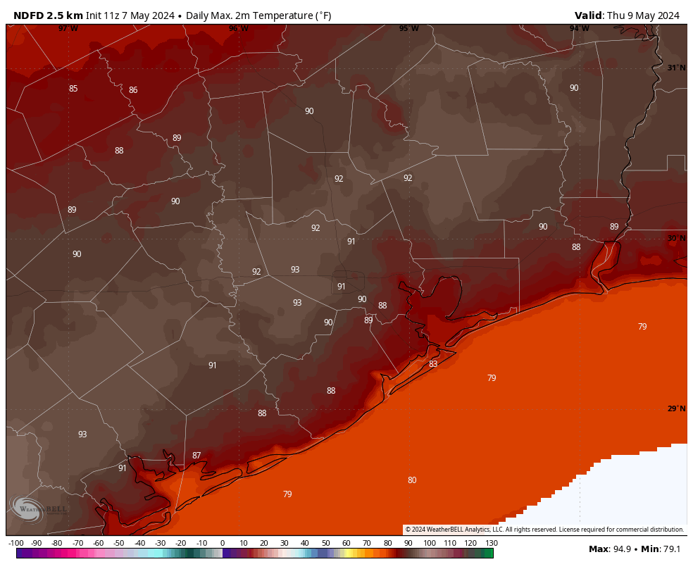
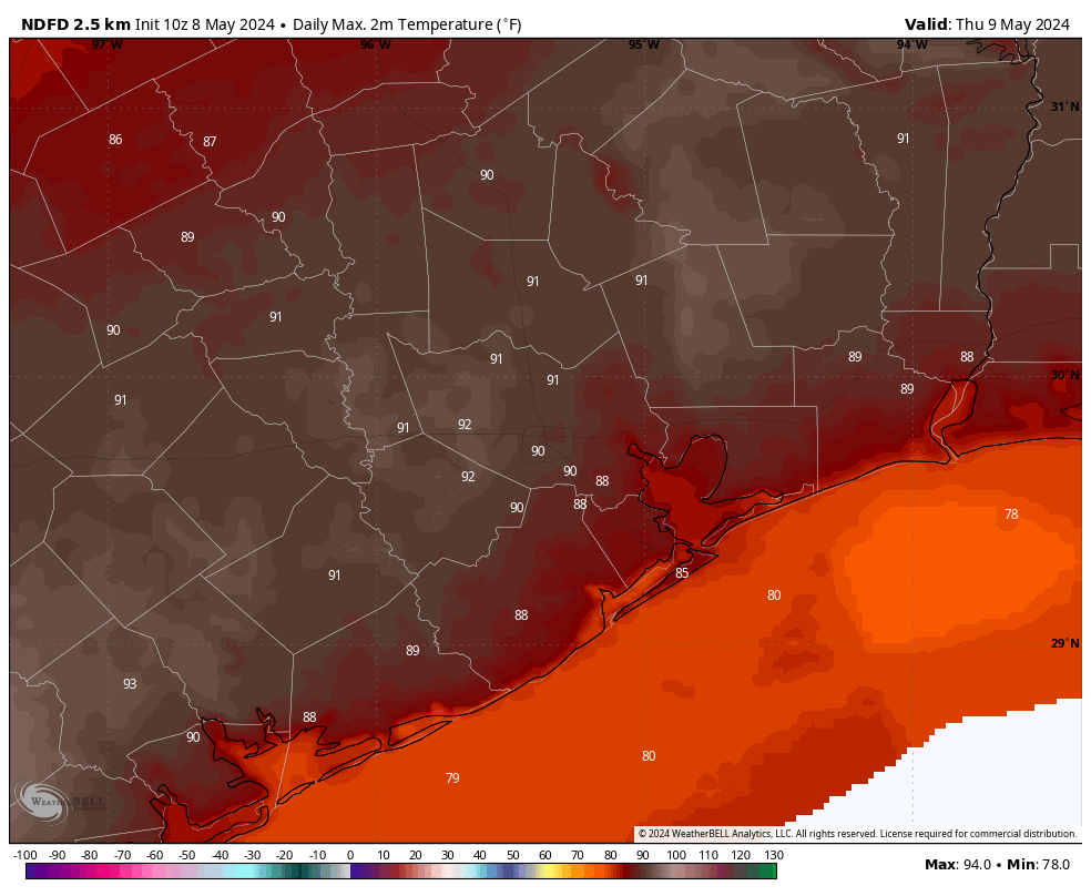
Another warm day. I think this will be the warmest of the week, with much of Houston likely reaching 90 degrees or a tick above. There may be a little more sunshine to help push temperatures up. If we look at the atmospheric profile, we see a fairly strong capping inversion that will help to prevent lift. However, if this cap breaks we could see some isolated showers and thunderstorms later on Thursday. Chances are probably less than 20 percent. Expect another warm night.

Friday

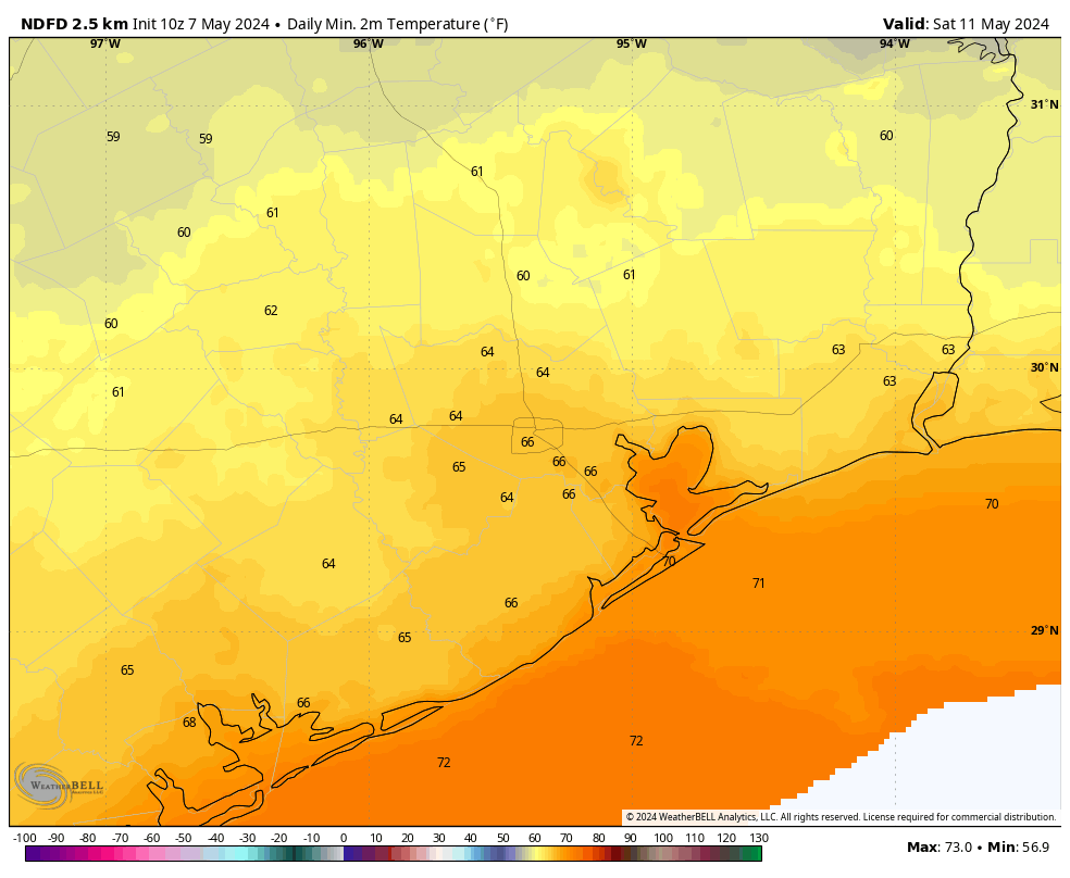
A weak front—there’s rarely any other kind this time of year, and we ought not to complain—will move through Houston on Friday morning. This will eventually bring some drier air into the region, but the day will start out fairly humid. Highs will likely reach the mid- to upper-80s beneath mostly sunny skies. Lows on Friday night will drop into the 60s for most locations, although how far will depend on your distance from the coast.

Saturday

The first half of the weekend looks splendid for mid-May. We’re talking partly sunny skies, with highs in the low- to mid-80s. The driest air will be found on Saturday morning, with dewpoints in the 50s. If you get out and walk, run, or bike that morning it should feel really comfortable. The onshore flow returns pretty quickly, however.

Excessive rain outlook for Sunday and Sunday night. (NOAA)

Sunday

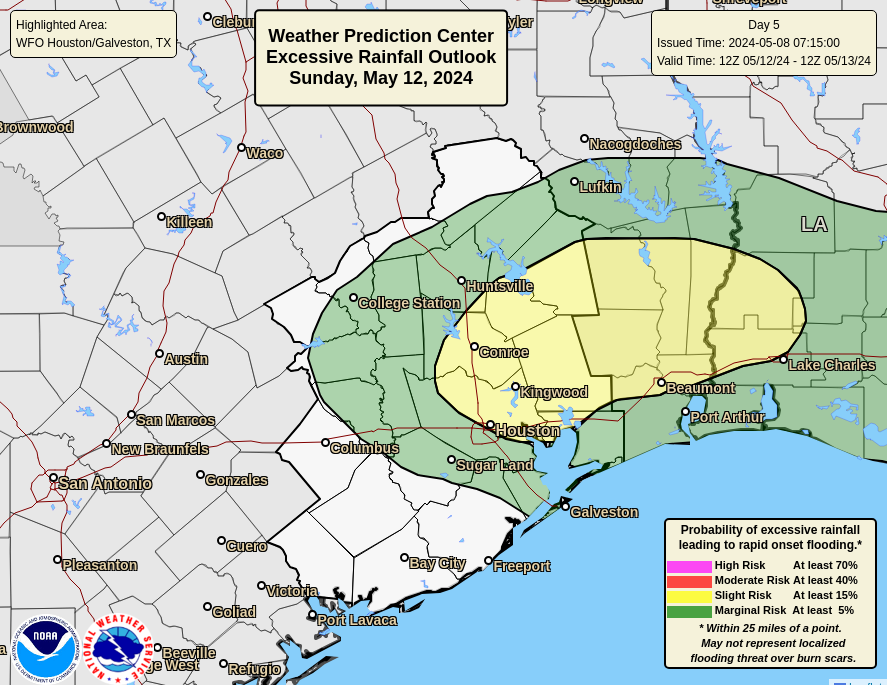
Mother’s Day will have less sunshine, more humidity, and a decent chance of rain. Sorry, mom. Highs will likely top out in the low 80s. As high pressure moves away it will open up the region to a series of disturbances on Sunday and Monday. I don’t think we should be overly concerned about heavy rainfall, but the details are hard to parse at this point. It does look as though much of the area may see 1 to 2 inches of rain during the Sunday to Tuesday period. So expect scattered to widespread showers on Sunday.

Next week

More of the same is likely on Monday, with lesser rain chances later in the week. Highs next week look to return to the upper 80s or thereabouts. Humidity levels don’t look quite as high as we’re seeing at present.

Help with flooding study

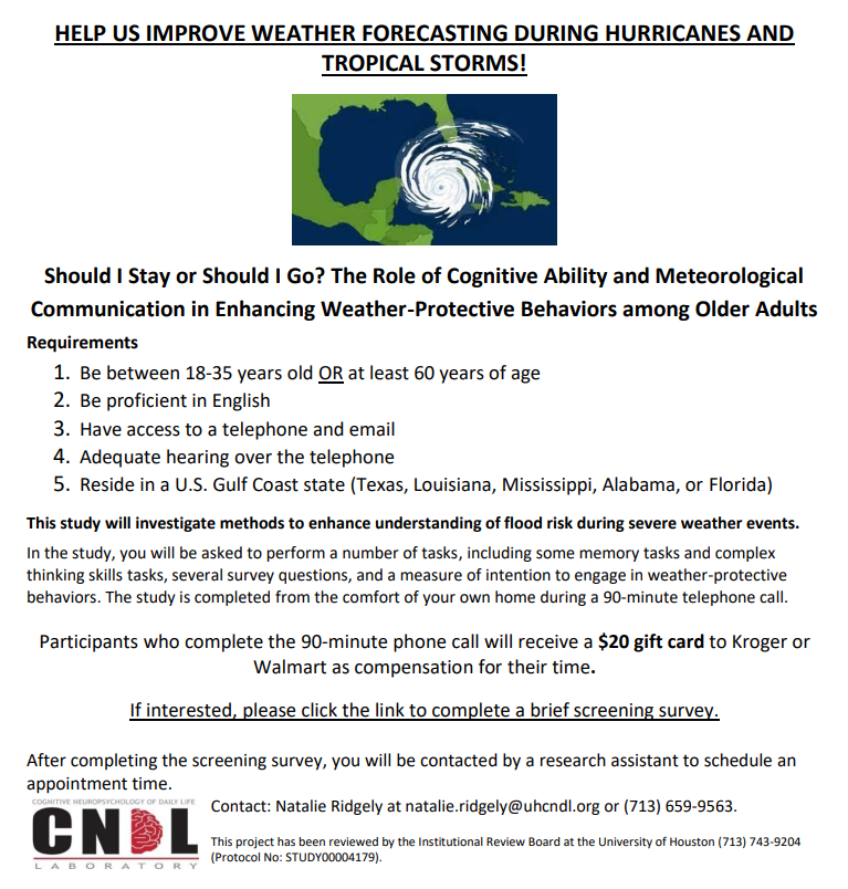
We are excited to announce a research partnership with the University of Houston! For our first project, we are trying to understand how people respond to different levels of flood risk during severe weather events. We are looking for people over the age of 60 or under the age of 35 to participate in a 90-minute, in-home telephone call during which they will complete some tests of thinking skills (e.g., memory), survey questions, and weather-related tasks. Participants who complete the study will receive a $20 gift card to either Walmart or Kroger. If you are interested in participating in this study, please click here.

Houston’s forecast has a little bit of something for everyone in the next 10 days

In brief: Whether you like hot or cooler conditions; humidity or drier air; sunshine or clouds; and rain or not, Houston will offer a little bit of all of that in the middle of May. In the near term we’re going to be hot and sunny, although not blistering hot. Conditions turn a bit cooler toward the weekend, and Mother’s Day weekend looks rather nice. Expect some rain next week.

Tuesday

Will Houston hit 90 degrees for the first time this year, officially? The city’s main weather station at Bush Intercontinental Airport has gotten close this year, but not hit the mark. Today is a probably, as skies should turn mostly sunny by the afternoon hours. Winds will be fairly light, from the southwest at 5 to 10 mph. Highs will likely reach about 90 degrees for most of the area except for coastal counties. Lows tonight will drop into the mid-70s.

Wednesday

Pretty much a carbon copy of Tuesday, except for slightly windier conditions at the surface, with southerly gusts up to 25 mph. Highs may be a degree or two warmer.

Thursday now looks to be the hottest day this week. (Weather Bell)

Thursday

This will be another warm and partly to mostly sunny day. The difference is that we may see a few scattered showers and thunderstorms as a front approaches the metro area. But I think we’ll stay dry for the most part. Highs will be around 90 again, with some inland areas possibly reaching the low 90s as temperatures jump up a bit ahead of an advancing front. Expect another warmish night as drier air doesn’t really begin to arrive until Friday morning. The front’s passage looks mostly dry.

Friday

A nice day, with mostly sunny skies and highs in the mid-80s. With dewpoints in the 50s, the air will feel nicely dry for May. The morning could be breezy as said air moves in. Lows on Friday night will likely drop into the mid-60s.

Saturday

This will be about as nice a day as one could hope for in mid-May. We’re looking at highs in the low- to mid-80s, with dry air, and partly sunny skies. Another night in the mid-60s is likely.

Low temperature forecast for Saturday morning. (Weather Bell)

Mother’s Day

The latter half of the weekend should see the introduction of some more clouds, and slightly more humid air. Look for highs in the low 80s. Some slight rain chances return on Mother’s Day, as a series of disturbances approach from the west. At this point, however, I think daytime shower chances are fairly low, perhaps on the order of 10 to 30 percent.

Next week

I don’t have a great handle on the details, but the pattern change that begins on Sunday likely accelerates Monday and brings a much better chance of rain. Decent rain chances may persist for much of the next work week. I don’t feel comfortable speculating on accumulations, but something roughly on the order of an inch or so for most locations seems like a decent guess. It doesn’t look like anything extreme, at least at this distance.

Looking back at last week’s exceptional rains; and forward to not one, but two fronts

In brief: Well, it’s over. In today’s post we discuss last week’s extraordinary precipitation event that finally ended Sunday, and some lessons learned. Houston faces calmer weather this week, with two frontal boundaries coming later this week and over the weekend to bring some drier and slightly cooler air into the region. Unfortunately it does appear as we’ll see some decent rain chances on Mother’s Day.

Seven-day rainfall totals for the period ending Sunday morning. (NOAA)

A week of rains

The map above shows rainfall totals over the last week, and for locations north of Interstate 10 they’re pretty incredible. Some locations in Walker and San Jacinto counties recorded in excess of 25 inches of rainfall, and closer to Houston eastern Montgomery County picked up 15 inches of rainfall. The southern half of the region, by contrast, saw significantly less rainfall.

Matt and I have taken away a couple of lessons from this. First of all, it’s a reminder of the unpredictability of these kinds of rain events, where you have slow-moving boundaries that are able to tap into ample moisture from the Gulf of Mexico. These springtime rains are among the hardest to predict. To wit, as late as last Tuesday we were calling for 0.25 to 2 inches of rainfall for the week, and saying, “These are likely to be garden-variety showers rather than anything too intense or organized.” Obviously that was a huge, humbling miss. We weren’t alone in that miss, and no one was predicting what ultimately happened. But it’s safe to say this is a learning opportunity for us.

We also are going to continue to tweak our flood scale. For much of the Houston metro area last week’s rains provided some on-and-off street flooding, but nothing more. Our Stage 1 and Stage 2 warnings largely reflected the urban flooding risks. But for neighborhoods along and near the San Jacinto River, these were catastrophic floods, closer to Stage 4. We need to address this discrepancy in a future version of our flood scale. The good news is that we’re working with a local university to include public feedback into this upgrade, and you’ll have a chance to participate. Look for that opportunity later this week.

In summary, this was a badly forecast rain event. I am glad it is over. It was, frankly, a nightmare to forecast. Matt and I lost a lot of sleep. We will learn from it and do better in the future.

Monday

We are transitioning to a pattern with higher pressure this week, and that will bring an end to unsettled weather for awhile. There will still be perhaps a 10 to 20 percent chance of rain today, but any showers that develop will be scattered to isolated, and fairly short lived. Otherwise expect partly to mostly cloudy skies, with highs in the mid-80s. Winds will blow from the southeast at about 10 mph, with gusts up to 20 mph. Lows tonight will be muggy, with temperatures dropping only into the mid-70s.

Wednesday could be the hottest day of the week. (Weather Bell)

Tuesday, Wednesday, and Thursday

These likely will be the warmest days of 2024 so far. Expect highs to reach about 90 degrees each day in Houston, with slightly warmer conditions to the west of the city and slightly cooler daytime highs near the coast. Skies will be partly sunny with a decent southerly breeze. Nights will be warm, in the 70s. It’s been awhile since we’ve experienced this kind of heat and humidity, so please give your body some time to acclimate.

Later on Thursday, or perhaps Thursday night, we could see the return of some rain chances as a front pushes into the Houston metro area. The timing of this is still a bit fuzzy, so it’s not clear whether we’ll see any cooling on Thursday. I tend to doubt it.

Friday

Highs on Friday should be cooler, in the mid-80s, with the influx of drier air. I think we’ll see partly to mostly sunny skies, with lows dropping into the 60s. This weather won’t be chilly by any means, but it does offer a nice reprieve from the heat and humidity earlier in the week.

Saturday and Sunday

Saturday should see the driest air of the week, with dewpoints perhaps dropping into the 50s. I think we’ll see high temperatures in the low 80s for both days this weekend, with partly sunny skies. In terms of lows, we’re probably looking at the 60s, but I don’t feel super confident yet in overnight temperatures. Unfortunately for Mother’s Day, as a secondary front approaches, I think we’ll see an increase chance of rain showers—probably not anything too serious but enough to put a damper on things. If you have outdoor plans for next Sunday, please keep an eye on the forecast.

Note these are dewpoints, not temperatures on Saturday morning. But just wanted to point out that drier air in mid-May is always a delight. (Weather Bell)

Next week

We may continue to see temperatures in the 80s for much of next week, with lows in the 60s to start the week before we return to the 70s. After some rain chances on Sunday and Monday, we should settle back down to partly sunny skies. In any case, two fronts in the middle of May are more than welcome in my book.

Heavy thunderstorms will traverse much of the Houston area this morning with street flooding likely in spots

In brief: Morning rain has thus far been manageable, but repeated rounds of thunderstorms along and on either side of I-10 will likely cause ponding and street flooding in spots this morning and afternoon. Flood Watches remain in effect through evening.

Happening now

One round of heavy rain and storms has exited to our east. Rain totals from that round were manageable in the Houston area and most points north to Conroe. A couple flash flood warnings were needed north of Lake Livingston and back into Huntsville, where totals approached two inches. Now, we’re seeing a west-east line of storms from northern & central Harris County back past Columbus.

Radar as of 8:30 AM shows periods of heavy rain and thunderstorms lined up from northwest of Houston back past Sealy and Columbus. (RadarScope)

Rest of today

This line of storms will likely “train” west to east through the morning and early afternoon. This means repeated rounds of storms basically within 20 miles of either side of I-10. For now, there are enough gaps in between downpours to keep things mostly just annoying and not troublesome. If that continues like that the rest of today, we’ll be fine; yes there will be roadway ponding or localized street flooding but probably nothing much worse.

Rain totals should be on the order of 1 to 2 inches, with higher amounts likely depending on exactly where and how frequently storms “train” over the same areas. Lesser amounts south and well north. (Pivotal Weather)

Eric and I have been wary about things this week because, frankly, most model guidance has struggled. But in general, things seem to be doing what was expected. So, thunderstorms this morning on both sides of I-10. Look for these to continue into early afternoon. Some scattered activity may pop up north of Harris County this afternoon, and we’ll watch for localized downpours up that way. The NWS Flood Watch continues through evening, and our Stage 2 flood alert will continue with that as well. If, for some reason this band of storms shifts farther to the north, it will not take a lot to begin flash flooding. And if for some reason, the rains over Houston remain heavy with fewer breaks, we could see more widespread street flooding. So that’s why we’ll maintain that Stage 2.

Editor’s Note: The National Weather Service Weather Prediction Center issued a discussion while I was editing this post, suggesting that heavier rain over the Houston area was likely through afternoon and could lead to more widespread street flooding. We’ll continue to watch this through the day.

Totals, as you can see from above should be generally 1 to 2 inches, with isolated higher amounts possible. Lower amounts toward the coast and perhaps to the north. Obviously, it’s been pretty rough this week in terms of forecasts and impacts, so continue to monitor the situation, and we’ll post later if anything seriously changes.

Conditions should improve this evening.

Monday and beyond

We finally begin to unwind this disrespectful weather pattern. Temperatures will begin to heat up, and we still expect low to mid-90s into midweek. Rain chances won’t be zero, but they’ll be much lower than they’ve been in recent days.

Even though the rain will quiet down, river flooding will continue this week. One river we have not discussed much is the Brazos. Things have been fine there, but the river is likely to continue rising all week and may even approach moderate flood levels by late in the week.

The forecast for the Brazos at US-59/I-69 shows a steady rise in the river all week, reaching near moderate flood by the end of the week. (NOAA)

Beyond Friday, it’s a bit uncertain still, but assuming the river hits 68 feet or so, we’ll begin to see the flood plain get inundated, requiring the relocation of cattle. We’ll monitor this in the coming days; thankfully there’s time to prepare.