After three years of owning a whole-home generator, here’s how things have gone

In brief: In this sponsored post with longtime partner Reliant, Eric writes about his experiences with owning a whole-home generator, including during recent storms. If you’re thinking about getting one, now is a good time. If you start the process today, there is still time for a generator to be installed prior to the busy part of the 2024 Atlantic hurricane season. Additionally, there is a special Reliant offer for our readers—read to the end for more details on that.

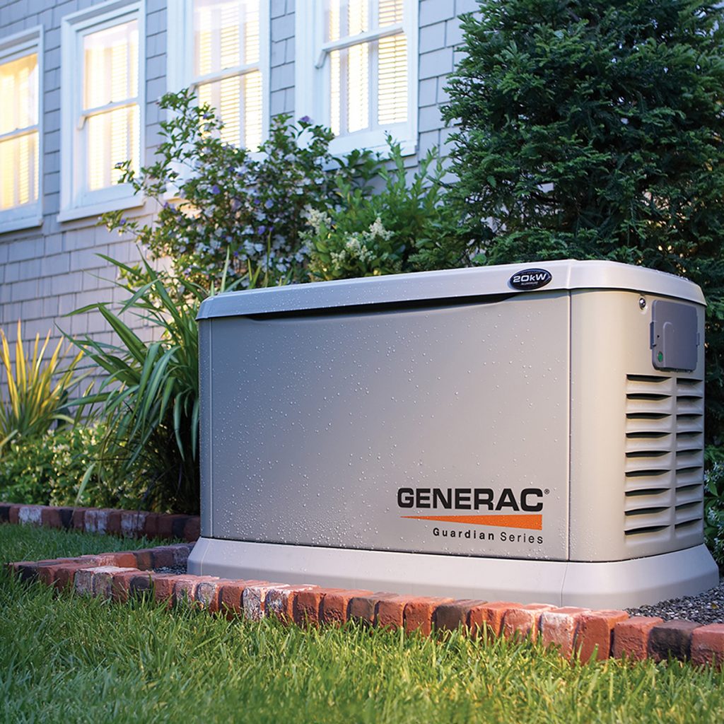
Hurricane season is right around the corner, but we are still about four months away from the time when Houston typically is most at risk for damaging tropical weather. So if you’ve been thinking about a whole-home generator, now is the time to order to have it running by peak season. You may recall that I had one installed by Quality Home Products, who partners with Reliant, about three years ago. I want to provide an update on how it has performed since then.

Surviving the storm

Truth be told, it has mostly just existed in the background. It’s kicked on a few times, during brief power outages, but until recently nothing serious.

Also, thanks to my preventative maintenance plan, it gets checked out a couple of times a year. However, in late March, I experienced my first problem. The generator didn’t run for its weekly test and the red service light came on.

What a standard residential generator looks like. (Generac)

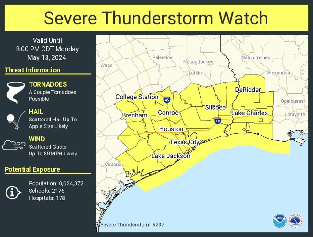
One of the things I like about Quality Home Products is that when you call the service number, a real person answers right away. She was helpful, and sent out a technician a couple of days later. He fixed the problem, which involved a battery and a motor. And it’s a good thing, too. Because a couple of days later, early on the morning of April 10, we had some strong storms move through. You may remember them. The winds were especially nasty in our neighborhood. Briefly, they were pretty scary. We lost two mature trees, twisted and snapped in half. My daughter’s trampoline was picked up, turned on its side, and the metal poles were broken. These were violent storms.

The power went off in the heart of the storm, but seconds later the generator kicked on just as it’s supposed to do. It ran without difficulty for the next 16 hours until power was restored. (Several nearby power poles were snapped in half and had to be replaced). It was, shall we say, a comfort. And it all happened without me having to do a thing.

Not a small project

I want to be clear. Buying a generator capable of powering your entire home is a major investment. I feel very fortunate to have one. For the average homeowner in Houston, it will likely cost between $10,000 and $15,000. The entire process from an initial consultation to installation will take at least six to eight weeks.

Buyers have lots of options, but having lived the experience with Reliant and Quality Home Products, I can say the service is excellent and reliable. The peace of mind it brings is comforting during severe weather.

Reliant customer reader offer: For now through the end of June, Reliant customers can get $1,000 off a generator from Quality Home Products and one year of free preventative maintenance. For more information, please visit this website.

A couple of quieter days before rain chances return on Thursday

In brief: After widespread showers and thunderstorms on Monday, clearer skies and calmer weather will prevail on Tuesday and Wednesday. However we’ll return to a wetter pattern on Thursday that will bring another chance of heavy rain, especially to areas north of Houston. The weekend looks sunny and hot, with summer on the near horizon.

A rare spring-time morning in mid-May in Texas. (Weather Bell)

Tuesday

After a weak front pushed into Houston on Monday night, we’re seeing slightly drier air and pleasantly cooler temperatures this morning. Lows have fallen into the mid-60s for much of the region. With clear skies and somewhat lower humidity, highs today will push into the upper 80s to 90 degrees across the region, with the warmer temperatures coming further inland. Winds will be light, from the northwest. Lows should again drop into the 60s tonight for all but coastal areas.

Wednesday

This will be another sunny day with highs near 90 degrees. Winds will shift to come from the southeast later in the day, a harbinger of more moisture to come. Still, humidity levels will be low-ish during the daytime before a more humid evening. Expect lows in the low 70s.

Thursday

As atmospheric moisture levels increase, we’ll see a series a disturbances pass overhead on Thursday and Thursday night. There is not a particularly strong signal for severe weather such as wind or hail. However, there is the possibility of heavy rainfall. I’m not fully convinced this forecast will verify, but much of the Houston area could see an additional 1 to 3 inches of rainfall. My concern is for areas north of Houston, which have already been battered by heavy rainfall this month. Areas such as Huntsville and Lake Livingston could see bullseyes of 4 or more inches of rainfall. Widespread clouds and rains should limit highs in the 80s.

NOAA rain accumulation forecast for Thursday and Thursday night. (Weather Bell)

Friday

Rain chances will persist into Friday morning, but things should taper off at some point during the late morning or early afternoon. Expect partly sunny skies later in the day, with highs in the upper 80s.

Saturday and Sunday

The weekend looks mostly sunny and warm, with temperatures in the range of 90 to 93 degrees for most locations. Nights will drop into the low 70s. Plan your outdoor activities with confidence.

Next week

Most of next week looks partly to mostly sunny and warm, with highs in the low 90s. Rain chances look fairly low. As we get into the back half of May we’re staring squarely into the face of summer, my friends.

Strong thunderstorms are inbound to the Houston area: Please be weather aware this afternoon

In brief: Strong thunderstorms are approaching Houston from the southwest and will soon spread into the metro area. The period of 2 pm to 6 pm should see the strongest storms, with hail, damaging winds, a few tornadoes, and some street flooding possible. Please take this threat seriously.

As expected, we are seeing the development of strong thunderstorms to the southwest of Houston this afternoon. These storms will gradually progress eastward through the afternoon and early evening hours before they exit to the east. At this point the most severe weather appears likely to occur along and south of Interstate 10.

A severe thunderstorm watch is in place for the entire Houston metro area today. (National Weather Service)

In terms of timing, I anticipate that showers and thunderstorms will begin to develop widely across much of the Houston metro area by around 1:30 to 2 pm. A more organized line of severe thunderstorms will subsequently march across the area from west to east from 3 to 6 pm. The strongest storms should be east of Houston before sunset, with some light showers possibly lingering a little while longer.

There is a fairly high risk of hail with these storms, particularly along and south of Interstate 10. The National Weather Service indicates that a few areas may see hail as large as an apple, but for most locations any hail that falls should be smaller than this. Damaging winds are also possible, as well as a few isolated tornadoes. Heavy rain will also accompany these storms, but the most intense showers should progress fairly quickly. Thus, while some street flooding is possible, we are not overly concerned about a significant flooding event.

We will clear out this evening, and then have a couple of calm days before rain, and possibly storm, chances return Thursday. Stay safe out there, y’all!

Severe weather likely today as a weak front moves into Houston: Damaging winds, hail are possible

In brief: Storms are likely in Houston today, after noon. The line of showers and thunderstorms may hit the area during the critical hours after school, or during the early portions of the evening commute, so please remain weather aware. After that we will have a couple of calmer weather days.

Monday

A number of ingredients for severe weather are stacking up this morning across the Houston area, including atmospheric moisture, instability, shear, and a trigger in the form of a weak front that will push through. All of these factors are likely to produce a line of showers and thunderstorms, some of which will be severe, that will move through Houston from northwest to southeast during the afternoon hours today.

There is an ‘enhanced’ risk of severe weather for parts of the Houston metro area today. (NOAA)

In terms of timing, I expect conditions to warm and muggy this morning, with temperatures in the 80s and mostly cloudy skies. The action is likely to pick up shortly after noon, to the west of Houston. Locations such as Katy and The Woodlands are like to see the onset of storms between 2 and 4 pm, with the line moving into central Houston later this afternoon, perhaps between 3 and 5 pm, and reaching the coast between 4 and 6 pm. I realize the timing here in unfortunate, likely affecting parts of the metro area during school pick-up, afternoon activities, and the evening commute. Please check the radar before venturing out—conditions will be better in some locations than others.

With regard to impact, the line of storms should be fairly progressive as it moves through the area. So the worst of the rain, lightning, and other impacts, including damaging winds, hail, and possibly a few tornadoes, should not last too long. But these conditions may be briefly intense. Some street flooding is also possible during the strongest storms, in which up to 3 inches may fall fairly quickly. After the initial line of storms showers may linger for another hour or two. The bottom line is that today will be a day to be weather aware, especially from noon to around sunset. Not all areas will be affected by severe storms, but it does look like a fairly good chunk of the region will be.

Severe hail is most likely to the west of Houston. (NOAA)

Temperatures tonight should fall into the upper 60s with mostly cloudy skies.

Tuesday

Expect sunnier skies and calmer weather in the wake of the front. Highs will reach about 90 degrees, aided by sunshine and the slight drier air that will allow them to pop up. Winds will be fairly light, from the north. Lows on Tuesday night should drop into the upper 60s again for most of the metro area, away from the coast.

Wednesday

Another sunny day with highs near 90 degrees. Winds will shift to come from the southeast during the day time, most likely, allowing for a slightly warmer and more humid night in the low 70s.

Lows in the 60s on Wednesday morning will not be unwelcome. (Weather Bell)

Thursday

More storm chances return on Thursday as the atmosphere becomes more amenable with passing disturbances. Right now let’s call for a likely chance of rain, but with lower confidence in the details. Expect highs in the mid-80s.

Friday

A chance of showers lingers, but the signal is not as strong for Friday. Look for highs in the upper 80s. Details to come.

Saturday and Sunday

The weekend looks mostly sunny. Saturday should bring temperatures in the upper 80s, with Sunday likely reaching the lower 90s. I can’t entirely rule out some passing showers on Saturday, but overall chances are near zero on Sunday.

Next week

It’s difficult to say too much, but at this point I expect summer lite conditions next week, with highs generally in the low 90s. High pressure looks to be mainly in control, but we’ll have to see if that actually comes to pass.